Mixed-theme Maps
京板天文全圖
Complete map of astronomy and the Qing Empire| Hanyu Pinyin | Jing ban tian wen quan tu |
|---|---|
| Creator | Ma Junliang |
| Date | Around the 55th Year of Qing Qianlong Reign, 1790 |
| Measurement | |
| Techniques | Woodcut and hand-colored |
| Material | paper |
| Quantity | |
| Categories | |
| Country of Repository | |
| Identifier | Library of Congress |
| Link to Original Database | http://lccn.loc.gov/gm71005137 |
| Acquisition Source | 美國國會圖書館東方部 |
| Acquisition Date |
| Share |
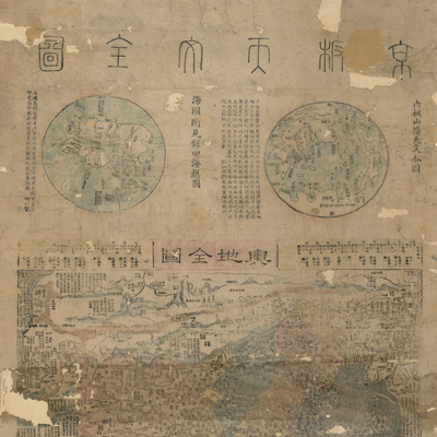
There are three maps with text on one sheet: one map of the east hemisphere and one map of the west hemisphere on top. “A complete map of the Qing Empire” appears on the bottom. The map on the top left is “A general map of four oceans with a record of things seen and heard in the maritime countries”. The explanatory text is collected from a map of the same name by Chen Lunjiong in the 8th Year of Qing Yongzheng Reign (1730). The map on the top right is the “Official complete map of astronomy, mountains, and seas”. It is a facsimile copy of the “Complete map of the Earth” made by Matteo Ricci in the 12th year of Wanli (1584). The map on the bottom, “Complete map of Qing Empire”, is an updated version of the same map made by Huang Zongxi in the 12th Year of Qing Kangxi Reign (1673).
Additional locations subjugated during the Qing Dynasty were added to the revised map: Taiwan, Mongolia's forty-nine banners (tribes), eight ethnic Miao groups, Dajianlu sub-prefecture (Kangding, Sichuan), Hami (Xinjiang), Khalkha (Mongol), Xitao (Mongol), regions surrounding the West Sea, and the changed watercourse of the eastern Yellow River. The map covers territory from the Tuci River (Tuul River, Mongolia) in the north to Wanlichangsha and the Wanlishitang islands of the South China Sea; from the Korean peninsula in the east to the Congling region (Pamirs) in the west. The map depicts Qing Dynasty territory, including Zhili, Shengjing, and seventeen other provinces. Different symbols are used to distinguish administrative regions. The neighboring regions and western countries are represented by symbols of islands with annotations.
The map can be studied with the following map in the National Palace Museum's collection: title: Kun yu quan tu (map no. 020786-020793).