Mixed-theme Maps
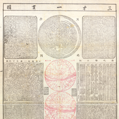
三才一貫圖
Map of the three powers unified| Hanyu Pinyin | San cai yi guan tu |
|---|---|
| Creator | Lu Anshi |
| Date | Early Qing period, 1722 |
| Measurement | |
| Techniques | Woodcut and color |
| Material | paper |
| Quantity | |
| Categories | |
| Country of Repository | |
| Identifier | Library of Congress |
| Link to Original Database | http://lccn.loc.gov/89691027 |
| Acquisition Source | Hummel, Arthur William, 1884-1975 |
| Acquisition Date | 1934 |
| Share |
The map consists of text blocks and six different maps and diagrams: a comprehensive map of heaven and earth; a perpetual map of the unified Qing Empire; the star chart of northern and southern hemispheres; a chronological chart of emperors; ancient He and Luo diagrams; and eight trigrams. Every map and diagram is copied from various earlier mapmakers, including Matteo Ricci, Ferdinand Verbiest, Wang Qi, and Huang Zongxi. It is a hybrid product of east and west in the form of maps, charts, and text. The content encompasses a wide variety of Chinese, Western, ancient, and modern knowledge that includes astronomy, geography, history, and ethics. It reflects the impact of western missionaries and the consequent cultural blend with the intention to reconcile traditional Chinese knowledge and western orientation. As a whole, from map content selection to design, great attention was paid to the harmony and unity of nature, pursuing a perfect scenario of the “unity of three powers” and reflecting the philosophy of “the unity of heaven, earth, and humanity”.
The map can be studied with the following map in the National Palace Museum's collection: title: Da Qing wan nian yi tong tian xia quan tu (purchase no. 002503-002510).
The map can be studied with the following map in the National Palace Museum's collection: title: Da Qing wan nian yi tong tian xia quan tu (purchase no. 002503-002510).