Maps of Social and Economic Conditions
閩省鹽場全圖
Complete map of salt fields in Fujian Province| Hanyu Pinyin | Min sheng yan chang quan tu |
|---|---|
| Creator | Pusabao |
| Date | The 11th Year of Qing Qianlong Reign, 1746 |
| Measurement | |
| Techniques | Ink and color manuscript |
| Material | paper |
| Quantity | |
| Categories | |
| Country of Repository | |
| Identifier | Library of Congress |
| Link to Original Database | http://lccn.loc.gov/gm71005065 |
| Acquisition Source | Hummel, Arthur William, 1884-1975 |
| Acquisition Method | |
| Acquisition Date | 1962 |
| Share |
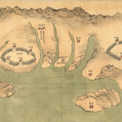
The map consists of two parts: Fujian and Taiwan. The map of Fujian is oriented with north to the right. Land is on top, the sea is at the bottom. The map shows white salt fields, yellow salt storage buildings with grey roofs, and yellow straw-covered salt piles. The map of Taiwan is oriented with north to the left and shows salt fields on the coast of Taiwan. Pusabao drew the map in traditional Chinese landscape painting style. Traditional mapping elements include its pictorial approach, its lack of scale, and its emphasis on mountains and water. The map covers areas of Taiwan Perfecture, Fengshan, Zhuluo, Zhanghua County, Funing Prefecture, Ningde County, Luoyuan in Fuzhou Prefecture, Lianjiang, Changle, Fuqing County, Quanzhou Prefecture, Hui'an, Nan'an, Tong'an County, Zhangzhou Prefecture, Haicheng, Zhangpu, Zhao'an County. The map depicts salt fields, mountains, buildings, walled cities, bridges, and temples pictorially. Notes on the map give distances between salt fields and salt storage centers. For centuries in China, salt was considered a 'treasure of the state' because salt and iron contributed more than half of the national revenue. The salt industry was a state monopoly.
The government controlled and regulated the manufacture, transport, storage, marketing, and distribution of salt. Commissioners were appointed to inspect and tax all salt produced. Salt smuggling and corruption were endemic and widespread in China. In the preface, Salt Commissioner Pusabao stated his resolve to carry out his responsibilities, determine tax levies, prevent smuggling, stop corruption, and clarify sources of revenue.
The map was made to serve these administrative purposes. The map can be studied with the following maps in the National Palace Museum's collection: title: Fujian Sheng di tu (map no. 021476); title: Zhou nan yan chang tu ji tu shuo (map no. 021014-021015).