Maps of Temples, Palaces and Royal Gardens
南岳全圖
Complete map of Nan Yue Mountain| Hanyu Pinyin | Nan Yue quan tu |
|---|---|
| Creator | Anonymous |
| Date | Late Qing period, 1860-1900 |
| Measurement | |
| Techniques | Ink and color manuscript |
| Material | paper |
| Quantity | |
| Categories | |
| Country of Repository | |
| Identifier | Library of Congress |
| Link to Original Database | http://lccn.loc.gov/gm71005105 |
| Acquisition Source | Hummel, Arthur William, 1884-1975 |
| Acquisition Method | |
| Acquisition Date | 1930 |
| Share |
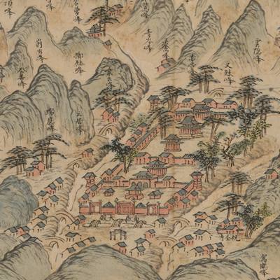
No title appears on the map; the title applied here is based on content. The map expands from right to left. It is oriented with north to the right; however, the map is not consistent with actual orientation. The map starts downstream at Changsha Prefecture and continues upstream to Hengzhou Prefecture.
The map depicts Xiangjiang riverbanks, Nan Yue Mountains, Hengshan County, Xiangtan County, Hengzhou Prefecture, and cities and towns of Changsha Prefecture. The map was drawn in a typical traditional landscape style with some features shown pictorially. The map depicts Nan Yue Mountains, temples, houses, bridges, and boats in vivid detail and resembles traditional Chinese paintings. The map deliberately enlarged the Grand Temple of Mount Heng for emphasis.
Every place name and mountain is recorded; the purpose of this map is for tourists or for pure artistic appreciation of landscape paintings.