Maps of Temples, Palaces and Royal Gardens
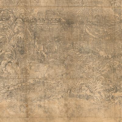
五臺山聖境全圖
Panoramic map of Mount Wutai| Hanyu Pinyin | Wutaishan sheng jing quan tu |
|---|---|
| Creator | Gelonglongzhu |
| Date | The 26th Year of Qing Daoquang Reign, 1846 |
| Measurement | |
| Techniques | Woodcut |
| Material | linen |
| Quantity | |
| Categories | |
| Country of Repository | |
| Identifier | Library of Congress |
| Link to Original Database | http://lccn.loc.gov/gm71005058 |
| Acquisition Source | Hummel, Arthur William, 1884-1975 |
| Acquisition Method | |
| Acquisition Date | 1934 |
| Share |
The map is seriously faded and the edges are battered and torn, but the title is still vaguely recognizable and is written in four languages: Manchu, Chinese, Tibetan, and Mongolian. Mount Wutain is located in northeastern Shanxi province. The mountain is home to many of China's most important monasteries and temples. It takes its name from its unusual topography, consisting of five rounded peaks (North, South, East, West, Central). Mount Wutai is one of the “Four Sacred Mountains” in Chinese Buddhism. Each of the four mountains is viewed as the place of practice of one of the four great bodhisattvas. Wutai is the home of the Bodhisattva of wisdom, Wenshu. The map depicts the locations of about fifty monasteries, especially Luohou Temple, White Pagoda, and Xiantong Temple of Taihuaizhen, which is located in the center of Mount Wutai. The map also illustrates pilgrims in worship.
The map can be studied with the following documents in the National Palace Museum's collection: title: Wutai wei dang, Jiaqing 16 nian; title: Qin ding qing liang shan zhi, vol. 22; title: Xi xun sheng dian, vol. 24.
The map can be studied with the following documents in the National Palace Museum's collection: title: Wutai wei dang, Jiaqing 16 nian; title: Qin ding qing liang shan zhi, vol. 22; title: Xi xun sheng dian, vol. 24.