Maps of Temples, Palaces and Royal Gardens
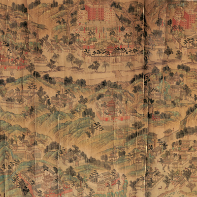
熱河行宮全圖
Bird's-eye view of Rehe Imperial Palace| Hanyu Pinyin | Rehe xing gong quan tu |
|---|---|
| Creator | Anonymous |
| Date | Qing Qianlong period, 1736-1775 |
| Measurement | |
| Techniques | Ink and color manuscript |
| Material | paper |
| Quantity | |
| Categories | |
| Country of Repository | |
| Identifier | Library of Congress |
| Link to Original Database | http://lccn.loc.gov/gm71005031 |
| Acquisition Source | Hummel, Arthur William, 1884-1975 |
| Acquisition Method | |
| Acquisition Date | 1930.06.24 |
| Share |
The bird's-eye view depicts a vast imperial garden and palace used by the Qing emperors as a summer residence. Rehe (Jehol) is situated northeast of Beijing, best known as the Rehe Imperial Mountain Resort during the Qing Dynasty. The Kangxi emperor started to build the palace in 1703; construction lasted throughout the eighteenth century. The Yongzheng emperors and Qianlong continued to build; the palace was finished in 1792. The resort covers 5,640,000 square meters. It is the largest royal garden in China. In summers, Qing Dynasty emporers came to the resort to escape Beijing's heat. The complex features large parks with lakes, pagodas, and palaces surrounded by a wall. The wall is more than 10,000 meters in length. Outside the wall are the Eight Outer Temples, built in varied styles. The Eight Outer Temples and the buildings in and around the palace are identified by pasted red labels. The mountains, trees, and walls are shown pictorially. The map was probably drawn during Emperor Qianlong's reign before 1775.
The map can be studied with the following three maps in the National Palace Museum's collection: title: Rehe bi shu shan zhuang tu (map no. 021499, 021527, and 021583).
The map can be studied with the following three maps in the National Palace Museum's collection: title: Rehe bi shu shan zhuang tu (map no. 021499, 021527, and 021583).