Political and Boundary Maps
廣西邊關形勢略圖
Sketch map of the Guangxi border| Hanyu Pinyin | Guangxi bian guan xing shi lue tu |
|---|---|
| Creator | Anonymous |
| Date | Qing Guangxu period, 1887-? |
| Measurement | |
| Techniques | Ink and color manuscript |
| Material | paper |
| Quantity | |
| Categories | |
| Country of Repository | |
| Identifier | Library of Congress |
| Link to Original Database | http://lccn.loc.gov/gm71005015 |
| Acquisition Source | Hummel, Arthur William, 1884-1975 |
| Acquisition Method | |
| Acquisition Date | 1930 |
| Share |
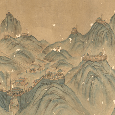
Drawn in traditional Chinese landscape style, the map depicts Zhennanguan Pass border defenses along the Guangxi and Vietnam border in the late Qing Dynasty. The map features intricate diagrams of mountains and connecting trails. The map's perspective is from outside of Zhennanguan Pass in Vietnam facing Chinese territory; the map is viewed from right to left as it expands. The map covers terrain from the Shuikoufeng fort on the right to Nanguangshi fort on the left. The map focuses on the terrain between the Guangxi and Vietnam border, including frontier defense, garrison locations, roads, and fort artillery positions. Zhennanguan Pass was an important fort connected to the Sino-Vietnamese border; the French army destroyed it during the Sino-French War. The war ended in the 11th Year of Qing Guangxu Reign (1885) when a peace treaty was signed. After the war, Zhennanguan Pass was rebuilt by Su Yuanchun (1844-1908, style name Zixi) who was the admiral of Guangxi in charge of frontier defense. The map shown here was created after Zhennanguan Pass was rebuilt between 1885-1903. The admiral “takes over the important strategic pass and builds 130 artillery forts on it”. There are three border forts in Guangxi along the China-Vietnam border: Zhennanguan, Pingerguan, and Shuikouguan.
The map shows only two forts, Zhennanguan and Shuikouguan; Pingerguan was either omitted or the middle part of the map is missing. This map can be studied with the following maps in the National Palace Museum's collection: title: Guangxi Sheng di tu (map no. 021516); title: Nanning Taiping Zhen Anshan Fu guan ai quan tu (map no. 021458).
The map shows only two forts, Zhennanguan and Shuikouguan; Pingerguan was either omitted or the middle part of the map is missing. This map can be studied with the following maps in the National Palace Museum's collection: title: Guangxi Sheng di tu (map no. 021516); title: Nanning Taiping Zhen Anshan Fu guan ai quan tu (map no. 021458).