City Maps
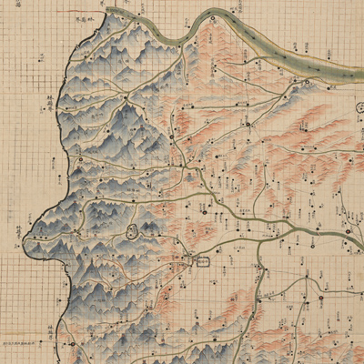
安陽縣全境輿圖
Map of Anyang County| Hanyu Pinyin | Anyang Xian quan jing yu tu |
|---|---|
| Creator | Anonymous |
| Date | Qing Guangxu period, -1902 |
| Measurement | |
| Techniques | Ink and color manuscript |
| Quantity | |
| Categories | |
| Country of Repository | |
| Identifier | Library of Congress |
| Link to Original Database | http://lccn.loc.gov/96685916 |
| Share |
The map title and scale are written on the top right. A side of each grid represents 1 li (approximately 0.33 miles). A detailed legend and compass rose are on the top right. The map uses a combination of modern mapping technology and the traditional Chinese grid system. The map depicts Fuguo County and Anyang County in Zhangde Prefecture, Henan Province. The mountains are shown pictorially; the elevation is shown by shading; rivers, cities, towns, villages, temples, and roads are drawn proportionally and vividly. The Hanling Mountain and the old road of Zhang River in the northeast are depicted in great detail. A few non-Anyang places are included; one of them resembles the “Enclave”.
The map can be studied with the following map in the National Palace Museum's collection: title: Henan Zhangde fu dao li tu (map no. 021436).
The map can be studied with the following map in the National Palace Museum's collection: title: Henan Zhangde fu dao li tu (map no. 021436).