City Maps
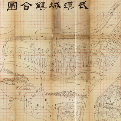
武漢城鎮合圖
Map of cities and town in Wuhan| Hanyu Pinyin | Wuhan cheng zhen he tu |
|---|---|
| Creator | Hubei guan shu ju |
| Date | The 3rd Year of Qing Tongzhi Reign, 1864 |
| Measurement | |
| Techniques | Woodcut |
| Material | paper |
| Quantity | |
| Categories | |
| Country of Repository | |
| Identifier | Library of Congress |
| Link to Original Database | http://lccn.loc.gov/gm71005123 |
| Acquisition Source | Qing government |
| Acquisition Method | |
| Acquisition Date | 1869 |
| Share |
North is at the top and the entire map is printed on a red grid, but there is no expressed scale. The map depicts street layouts, water systems, and three districts of Wuhan: Wuchang, Hanyang, and Hankou. Delicate images depict mountains and simple lines represent the Yangtze River, Hanjiang. The map shares some modern mapping characteristics of city maps. Relief is shown pictorially with facade perspective instead of traditional symbols. City walls, gates, bridges, government offices, and other buildings are depicted in three-dimensional images.
The map can be studied with the following map in the National Palace Museum's collection: title: Wuchang cheng huan tu (Grand Council file no. 021268).
The map can be studied with the following map in the National Palace Museum's collection: title: Wuchang cheng huan tu (Grand Council file no. 021268).