Military and Traffic Maps
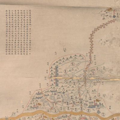
豫省輿圖
Map of Henan Province| Hanyu Pinyin | Yu Sheng yu tu |
|---|---|
| Creator | Anonymous |
| Date | Mid-Qing period, 1832-1855 |
| Measurement | |
| Techniques | Ink and color manuscript |
| Material | |
| Quantity | |
| Categories | |
| Country of Repository | |
| Identifier | Library of Congress |
| Link to Original Database | http://lccn.loc.gov/gm71005030 |
| Share |
The map adopts the traditional Chinese landscape style with relief shown pictorially. The map depicts the mountains, rivers, strategic position checkpoints, historical sites, and the government administrative divisions at all levels, including prefecture, state, subprefecture, and county for Henan Province. The map gives distance mileage between relay stations and cities; between Beijing and the border of Henan Province. Notes on the top left explain that the map was adapted, revised, and updated from “Zhongzhou Annals”, “Xing shui chronicles”, and “Hui dian Zhili provincial map”. The map contains a legend, for example, big squares stand for prefectures; small squares for subprefectures; orthorhombic circles for states; circles for counties. Double black lines represent travel routes and distance mileage between relay stations; black lines mark the travel routes by land. The map highlights the image of the Yellow River and notes the distances between cities. To quote the mapmaker's words: “Henan Province is vast so it is difficult to grasp its geographical features at one glance”.
The comments indicate that the purpose of the map is to emphasize the relative geographical position of places and features on the map. This map can be studied with the following maps in the National Palace Museum's collection: title: Henan Sheng di tu (map no. 021446); title: Henan quan sheng dao li tu (map no. 021578-021579).
The comments indicate that the purpose of the map is to emphasize the relative geographical position of places and features on the map. This map can be studied with the following maps in the National Palace Museum's collection: title: Henan Sheng di tu (map no. 021446); title: Henan quan sheng dao li tu (map no. 021578-021579).