Military and Traffic Maps
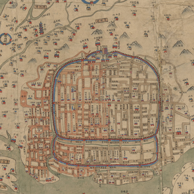
廣東通省水道圖
Map of the Waterways in Guangdong Province| Hanyu Pinyin | Guangdong tong sheng shui dao t |
|---|---|
| Creator | Anonymous |
| Date | Qing Jiaqing period, 1812-1816 |
| Measurement | |
| Techniques | Ink and color manuscript |
| Material | |
| Quantity | |
| Categories | |
| Country of Repository | |
| Identifier | Library of Congress |
| Link to Original Database | http://lccn.loc.gov/gm71002467 |
| Acquisition Source | Hummel, Arthur William, 1884-1975 |
| Acquisition Method | |
| Acquisition Date | 1930 |
| Share |
The map was drawn in traditional Chinese landscape style. North is at the top. The map depicts landforms, coastal islands, towns, villages, roads, and checkpoints. The coastal waterways, patrol divisions, checkpoints, and barracks in Guangdong Province are all clearly marked in detail, and form the special feature of this map. The notes on the top give distance mileage for different travel routes to Guangdong. The distribution of towns and checkpoints is quite intensive and dense, and is represented by a symbol of a house; above the county level, the places are circled with symbols of four houses; only the map of the provincial capital was drawn in greater detail.
This map can be studied with the following map in the National Palace Museum's collection: title: Guangdong Sheng di tu (map no. 021477).
This map can be studied with the following map in the National Palace Museum's collection: title: Guangdong Sheng di tu (map no. 021477).