Flood Control and Embankment Maps
運泇捕上下泉六廳光緒二年搶修工程咨估圖
The Grand Canal embankment cost estimate map| Hanyu Pinyin | Yun jia bu shang xia quan liu ting Guangxu er nian qiang xiu gong cheng zi gu tu |
|---|---|
| Creator | Anonymous |
| Date | The 2nd Year of Qing Guangxu Reign, 1876 |
| Measurement | |
| Techniques | Ink and color manuscript |
| Material | paper |
| Quantity | |
| Categories | |
| Country of Repository | |
| Identifier | Library of Congress |
| Link to Original Database | http://lccn.loc.gov/80692826 |
| Acquisition Source | Hummel, Arthur William, 1884-1975 |
| Acquisition Method | |
| Acquisition Date | 1962 |
| Share |
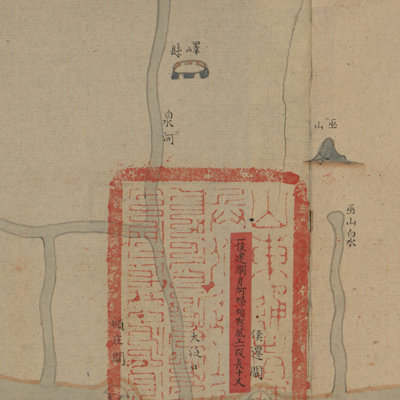
The map expands from right to left. It is oriented with north to the left but the map isn't onsistent with actual orientation. The map starts from Huanglinzhuang where Jiangnan Pizhou eets Yi County in Shandong, and ends at Zheyuanzhen where Dezhou, Shandong meets ingzhou, Zhili. The total length is 1,125 li and 180 steps (approximately 352 miles).
The map depicts fascine construction and fortification along the Grand Canal through six subprefectures n Shandong Province, including Yun He, Jia He, Bu He, Shang He, Xia He, and Quan He. The map describes topographies, embankment dams, lock-culverts, bridges, nd towns along the canal. Red labels pasted on the map identify construction sites and describe ascine reinforcement works and project length. The seals attached to the red labels are written n Manchu and Chinese. Water conservation engineering maps are usually made for a very pecific purpose. This map is a part of some sets made for water conservation and fascine reinforcement long the Grand Canal. This is a cost estimate map at the early stage of the project.
The map can be studied with the following maps in the National Palace Museum's collection: itle: Shandong Yanzhou Fu yu tu (map no. 021561); title: Ba sheng Yunhe quan yuan shui li ing xing tu (map no. 020912); title: Huang Yunhe gong cheng tu (map no. 020891-020910); itle: Jingkou yi xia Xiyang Yunhe yi dai he hu zhi Hangzhou qing xing (map no. 020881).