Flood Control and Embankment Maps
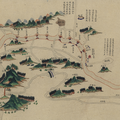
山東運河全圖
Complete map of the Grand Canal in Shandong Province| Hanyu Pinyin | Shandong Yun He quan quan tu |
|---|---|
| Creator | Anonymous |
| Date | Qing Guangxu period, 1877-1886 |
| Measurement | |
| Techniques | Ink and color manuscript |
| Material | paper |
| Quantity | |
| Categories | |
| Country of Repository | |
| Identifier | Library of Congress |
| Link to Original Database | http://lccn.loc.gov/gm71005023 |
| Acquisition Source | Hummel, Arthur William, 1884-1975 |
| Acquisition Method | |
| Acquisition Date | 1934 |
| Share |
The map expands from right to left with north to the left. The east side of the Grand Canal forms he top of map. The map starts from the south at Huanglinzhuang along the border of Jiangnan izhou to the north at Zheyuanzhen by the border of Jingzhou, Zhili Province. Drawn in raditional Chinese landscape style, the map depicts landforms along the Grand Canal, including ountains, lakes, sluice gates, embankment dams, culverts, cities, and towns. The Yellow River s drawn in yellow to differentiate it from other waterways. Detailed annotations along the anal describe the boundaries of the canal marshals' jurisdiction, river length and mileage, ranches, and engineering projects.
According to the text written across the town of Zhangqiuzhen, “New mouth of the Grand anal” and “the 3rd Year of Qing Guangxu Reign (1877) recently repaired”, the map was robably drawn after 1877.
The map can be studied with the following maps in the National Palace Museum's collection: itle: Shandong Yun He tu (map no 021588); title: Jiangnan Sheng Yun He ge ting shu he dao ha ba gong cheng qing xing tu (map no. 020911); title: Jingkou yi xia Xiyang Yun He yi dai e hu zhi Hangzhou qing xing (map no. 020881); title: Shandong Buhetingshu Shoudongxun alimiao gun shui shi ba bing jia zhu tu yan tu (Grand Council file no. 067800-a).