Flood Control and Embankment Maps
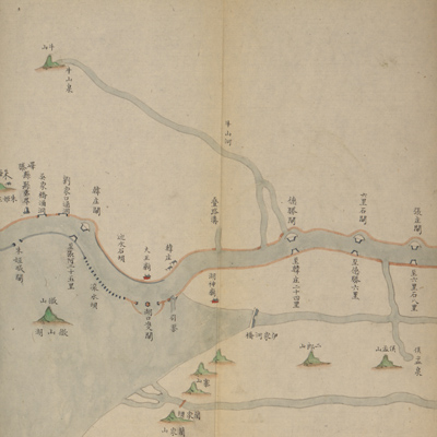
山東通省運河情形全圖
Complete map of the Grand Canal in Shandong Province| Hanyu Pinyin | Shandong tong sheng Yun He qing xing quan tu |
|---|---|
| Creator | Anonymous |
| Date | Late Qing period, 1855-1866 |
| Measurement | |
| Techniques | Ink and color manuscript |
| Material | paper |
| Quantity | |
| Categories | |
| Country of Repository | |
| Identifier | Library of Congress |
| Link to Original Database | http://lccn.loc.gov/80692829 |
| Acquisition Source | Hummel, Arthur William, 1884-1975 |
| Acquisition Method | |
| Acquisition Date | 1962 |
| Share |
The map expands from right to left with north to the left. The map starts with the east side of the Grand Canal on top. The beginning and ending of the map are identified respectively as “south” and “north” in Chinese characters to indicate orientation. The map starts from Huanglinzhuang at the junction of Jiangnan Pizhou and Yicheng County in Shandong Province; and ends at Zheyuanzhen at the junction of Dezhou, Shandong Province and Jingzhou, Zhili Province.
Drawn in traditional Chinese landscape style, the map depicts the landforms, sluice gates, embankment dams, and culverts along the Grand Canal in Shandong Province. Annotations describe the boundaries of the canal marshals' jurisdiction, river branches and water system distribution.
The map can be studied with the following maps in the National Palace Museum's collection: title: Shandong Yun He tu (map no. 021588); title: Huang Yun He gong cheng tu (map no. 020891-020910); title: Jiangnan Sheng Yun He ge ting shu he dao zha ba gong cheng qing xing tu (map no. 020911); title: Jingkou yi xia Xiyang Yun He yi dai he hu zhi Hangzhou qing xing (map no. 020881); title: Shandong Buhetingshu Shoudongxun Balimiao gun shui shi ba bing jia zhu tu yan tu (Grand Council file no. 067800-a).