Flood Control and Embankment Maps
浙江省垣水利全圖
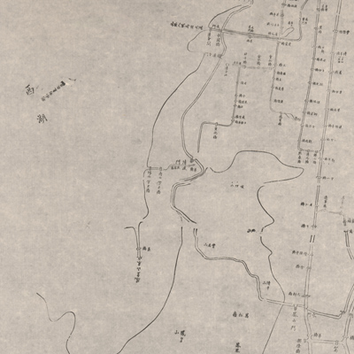
Hydrographic Map of Hangzhou, Capital of Zhejiang Province| Hanyu Pinyin | Zhejiang Sheng yuan shui li quan tu |
|---|---|
| Creator | Zhejiang guan shu ju |
| Date | Late Qing period, 1864-1874 |
| Measurement | |
| Techniques | Woodcut |
| Material | paper |
| Quantity | |
| Categories | |
| Country of Repository | |
| Identifier | Library of Congress |
| Link to Original Database | http://lccn.loc.gov/89691149 |
| Acquisition Method |
| Share |
The map depicts the water supply of the Hangzhou river systems in the capital of Zhejiang Province. Only bridges, sluice gates, water gates, and the lock gates by the junction are indicated on the map. The scale is not given; north is at the top.
The map can be studied with the following maps in the National Palace Museum's collection: title: Zhejiang Sheng hai tang (map no. 020880); title: Zhejiang Qiantangjiang shui lu tu (Grand Council file no. 033184).
The map can be studied with the following maps in the National Palace Museum's collection: title: Zhejiang Sheng hai tang (map no. 020880); title: Zhejiang Qiantangjiang shui lu tu (Grand Council file no. 033184).