Local Administrative Maps
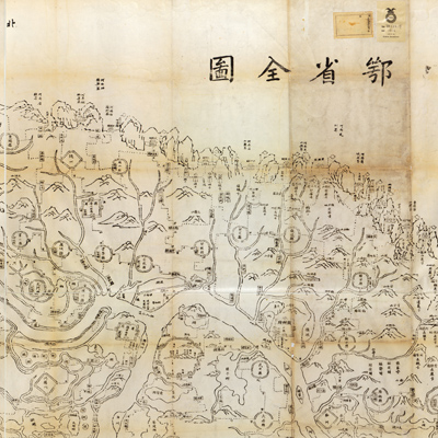
鄂省全圖
Complete map of Hubei Province| Hanyu Pinyin | E sheng quan tu |
|---|---|
| Creator | Yan Shusen |
| Date | The 1st Year of Qing Tongzhi Reign, 1862 |
| Measurement | |
| Techniques | Woodcut |
| Material | paper |
| Quantity | |
| Categories | |
| Country of Repository | |
| Identifier | Library of Congress |
| Link to Original Database | http://lccn.loc.gov/gm71005161 |
| Acquisition Source | Chinese government |
| Acquisition Method |
| Share |
The map is oriented with north at the top. There is no legend or scale. Notes at the top left give distances from Hubei Province to neighboring provinces and counties. The map depicts the administrative divisions, natural geographic features, various administrative centers, and detailed descriptions of the locations adjoining the Yangtze River and Han River; sand bars along the river are meticulously annotated. Mountains are shown pictorially; prefecture, state, county, and administrative offices are shown by squares, diamonds, and circled walls; rectangular for towns, relay stations, inspection and patrol divisions; watch towers indicate checkpoints; dotted lines are for the roads between towns with mileage given; double lines indicate regions the rivers flow through.
This map was drawn by Yan Shusen (? -1876, style name Weichun) who is the provincial champion of the Imperial Examination System in the 2nd Year of Daoguang Reign (1840). He became Hubei governor in Tongzhi reign (1862); He and Hu Linyi (1821-1861, style name Runzhi) compiled “Huang chao yi tong yu tu” (Complete map of the Qing Empire) in the 1st Year of Tongzhi Reign (1863).
This map can be studied with the following maps in the National Palace Museum's collection. Title: Han Jiang yi bei si sheng bian yu tu (map no. 021472); title: Han Jiang yi nan san sheng bian yu tu (map no. 0214730).