Local Administrative Maps
皇朝直省輿地全圖
Qing Empire's complete map of all provinces| Hanyu Pinyin | Huang chao zhi sheng yu di quan tu |
|---|---|
| Creator | Anonymous |
| Date | Qing Guangxu period, 1887 |
| Measurement | |
| Techniques | Lithograph |
| Quantity | |
| Categories | |
| Country of Repository | |
| Identifier | Library of Congress |
| Link to Original Database | http://lccn.loc.gov/gm71005103 |
| Acquisition Method |
| Share |
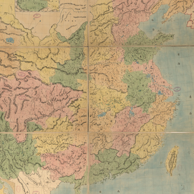
Notes on the map describe the land survey conducted by the Qing Government with assistance from Jesuits. The map includes an inset of Xinjiang on the top left and an inset of the East Hemisphere on the bottom left.
The map depicts the establishment of administrative divisions and the increasing coastal trading ports in the beginning of emperor Guangxu's reign. The prime meridian is Beijing. The full map coverage area is vast, though Tibet was not included. Each province is colored differently. Relief was shown by hachures, which means topographic features are expressed by the thickness and overall density of strokes and lines. A short, thick stroke represents a short and steep slope, while a long, thin stroke represents a long, gentle slope. Hachures expression suggests western mapmaking techniques were being utilized in China.
The map can be studied with the following maps in the National Palace Museum's collection: title: Shi san pai tong ban di tu (map no. 021049-021156); title: Zhongguo di tu (map no. 021504).