General Maps
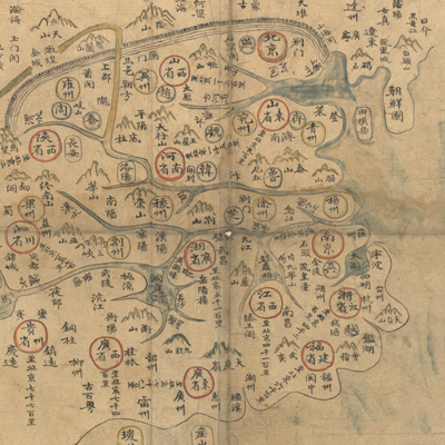
大明一統山河圖
The great Ming Dynasty's atlas of mountains and seas| Hanyu Pinyin | Da Ming yi tong shan he tu |
|---|---|
| Creator | Anonymous |
| Date | Early Qing period, 18th century |
| Measurement | |
| Techniques | Ink and color manuscript |
| Quantity | |
| Categories | |
| Country of Repository | |
| Identifier | Library of Congress |
| Link to Original Database | http://lccn.loc.gov/2002626778 |
| Acquisition Source | 華爾納(Warner, Langdon, 1881-1955) |
| Acquisition Method | |
| Acquisition Date | 1927 |
| Share |
The title on the cover is “Da Ming yi tong shan he tu”, but the title on the prefaceis “Da Ming yi tong tian xia tu,” which means “The Great Ming Dynasty's map of all under heaven.” The atlas consists of a map assembled from nine individual sheets. The map shows the territory of the Ming Dynasty, Manchuria, and Korea, including Beijing and Nanjing. The size of each sheet is different.The maps depict the administrative divisions of Beijing and Nanjing,thirteen provinces, mountains, prefectures, and counties during the Ming Dynasty. Different geometric symbols indicate the administrative units of the Xuanweisi Brigade, the Xuanwusi Brigade, the Zhangguansi Brigade, civilian,and military divisions. The legend also states that “one grid represents 100 li, and 1 foot represents 1,000 li” (1 li equals approximately 0.33 miles). The map not only covers the Ming territory, but also the Korean peninsula, Japan,the Ryukyu Kingdom, Champa (Vietnam), Brunei, and Khmer (Cambodia).
This map can be studied with the following map in the National Palace Museum's collection: title: Jiu bian tu (map no. 020846-020856).
This map can be studied with the following map in the National Palace Museum's collection: title: Jiu bian tu (map no. 020846-020856).