General Maps
天地圖
Atlas of Heaven and Earth| Hanyu Pinyin | Tian di tu |
|---|---|
| Creator | Anonymous |
| Date | Late-Ming period, ca. 1601 |
| Measurement | |
| Techniques | Woodcut |
| Quantity | |
| Categories | |
| Country of Repository | |
| Identifier | Library of Congress |
| Link to Original Database | http://lccn.loc.gov/2002626725 |
| Acquisition Source | Arthur William Hummel |
| Acquisition Method | |
| Acquisition Date | 1930 |
| Share |
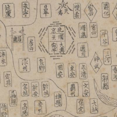
The title on the panel is “Guang yu tu” which means “The enlargement of the terrestrial map”, but the title on the map sheet is “Tian di tu pan yan”. Its content and form are similar to the map of “Guang yu tu” made by Luo Hongxian (1504-1564, style name Dafu, pseudonym Nian'an). The atlas consists of 20 maps in the following order: the first is a celestial chart followed by a general map of the Ming Dynasty; Beijing; Henan, Zhejiang, Jiangxi, Fujian, Guangdong, Guangxi, Nanjing, Shandong, Sichuan, Shaaxi, Shanxi, Huguang, Yunnan, Guizhou, Nuzhen Northeast Division, Southeast countries, and Northwest countries.
The maps depict the boundaries of Beijing, Nanjing, and thirteen provinces during the Ming Dynasty. Different symbols represent different levels of administrative divisions and the distribution of surrounding tribes. Administrative establishments are shown by squares, circles, ovals, diamonds, hexagons, pictorial houses, and other symbols; rivers and lakes use ripple-like images. The source of the Yellow River uses the shape of a gourd; mountains use chevrons; the Great Wall uses stacked straight lines. Based on the information, this map was drawn after the mid Wanli.
The maps depict the boundaries of Beijing, Nanjing, and thirteen provinces during the Ming Dynasty. Different symbols represent different levels of administrative divisions and the distribution of surrounding tribes. Administrative establishments are shown by squares, circles, ovals, diamonds, hexagons, pictorial houses, and other symbols; rivers and lakes use ripple-like images. The source of the Yellow River uses the shape of a gourd; mountains use chevrons; the Great Wall uses stacked straight lines. Based on the information, this map was drawn after the mid Wanli.