General Maps
分野輿圖
Atlas of the realm: cosmology and provinces| Hanyu Pinyin | Fen ye yu tu |
|---|---|
| Creator | Anonymous |
| Date | Mid-Ming period, 17th century |
| Measurement | |
| Techniques | Pen-and-ink |
| Material | manuscript |
| Quantity | |
| Categories | |
| Country of Repository | |
| Identifier | Library of Congress |
| Link to Original Database | http://lccn.loc.gov/2002626777 |
| Share |
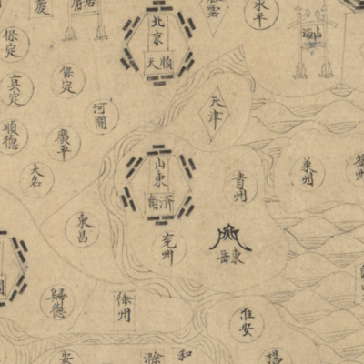
The atlas consists of 20 maps in the following order: the first is a celestial chart; followed by a map of the Ming Dynasty; Beijing; Nanjing; thirteen provinces; Manchuria Nuzhen; Southeast countries; and Northwest countries. No text or subtitles are used on any map sheets except place names. The maps depict the territory of the Ming Dynasty, the administrative divisions of Beijing, Nanjing, and thirteen provinces. Simple geometric symbols, including circles, squares, rectangles, diamonds, ovals, etc., depict administrative hierarchies and surrounding tribes.
Compared with the other maps, Beijing and provincial capitals are drawn in the different shape on this set; the source of the Yellow River is drawn in a three gourd shape; the Great Wall border crossings are depicted with Taoist amulets in the shapes of mountains or tribal gates.
Compared with the other maps, Beijing and provincial capitals are drawn in the different shape on this set; the source of the Yellow River is drawn in a three gourd shape; the Great Wall border crossings are depicted with Taoist amulets in the shapes of mountains or tribal gates.