Military and Traffic Maps
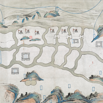
海防圖未完稿
Unfinished Coastal Defense Map| Hanyu Pinyin | Hai fang tu wei wan gao |
|---|---|
| Date | Middle Qing period (?). |
| Measurement | |
| Techniques | Ink and color manuscript |
| Material | paper |
| Quantity | |
| Categories | |
| Country of Repository | |
| Identifier | British Library |
| Link to Original Database | http://explore.bl.uk/primo_library/... |
| Notes | Maps 188.kk.1 (1) |
| Share |
This, as the title suggests is an unfinished map. The sea is at the top of the map and the mountain at the bottom. The map was executed in traditional Chinese brushstrokes. The ocean is depicted with sweeping light ink strokes. The map offers a look at the Chinese traditional impressionistic painting style. Towns and military posts are essentially complete; a blue rectangular box is left blank for text annotations. Military defense posts face the ocean. This is obviously a military map.