Military and Traffic Maps
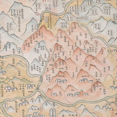
四川嘉定府周邊形勢圖
Military Map of Jiading Prefecture's Periphery| Hanyu Pinyin | Sichuan Jiading Fu xing shi tu |
|---|---|
| Date | Between the 55th year of Qing Qianlong's reign and the 13th year of Jiaqing's reign, 1790-1808. |
| Measurement | |
| Techniques | Ink and color manuscript |
| Material | paper |
| Quantity | |
| Categories | |
| Country of Repository | |
| Identifier | British Library |
| Link to Original Database | http://explore.bl.uk/primo_library/... |
| Notes | Add. MS. 16361 (T) |
| Share |
No title appears on this map; the title applied here is based on content. Scale, legend, and orientation are not given; north is at the bottom judging from locations on the map. The map offers pictorial depictions of sub-prefectures, counties, mountains, rivers, defense, and settlements of Jiading prefectures. The map also covers neighboring prefectures including Xuzhou, Chengdu, Yazhou, and Ningyuan, as well as the borders of Tibet and Yunnan. The Taiping Fort marked in the center is stressed on the map. Jiading was established as prefecture in the 12th year of Yongzheng, 1734, and governed seven counties.
The Mabian Sub-prefecture established in the 29th year of Qianlong’s reign, 1764, is shown on the map. Since the map shows the Taiping Fort established in the 55th year of Qing Qianlong’s reign, 1790, but not the Ebian Sub-prefecture, which was established in the 13th year of Jiaqing’s reign, 1808, this map may have been drawn during 1790 to 1808.
This map can be studied with the following maps in the National Palace Museum’s collection: Sichuan Sheng si lu guan yi tu (map no. 020801); Sichuan quan sheng dao li zong tu (map no. 021540-0215422); Sichuan Sheng tu (map no. 021459); Ping ding Jinchuan tu (map no. 021192-021223); Jin hui ju Yuejiao, Ebian, Qingqi jing nei yi fei zi shi di fang tu shui (map no. 064089); and the Library of Congress collection: Sichuan quan tu (gm 71005122); Quan Chuan ying xun zeng bing tu (gm 71005070); Sichuan, Hubei shui dao tu (gm 71005028).