Military and Traffic Maps
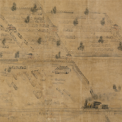
山海關全圖
Map of Shanhaiguan Pass| Hanyu Pinyin | Shanhaiguan quan tu |
|---|---|
| Date | After the 26th year of Qing Guangxu's reign, 1900-. |
| Measurement | |
| Techniques | Ink and color mauuscript |
| Material | cloth |
| Quantity | |
| Categories | |
| Country of Repository | |
| Identifier | British Library |
| Link to Original Database | http://explore.bl.uk/primo_library/... |
| Notes | Maps Tab.1.a |
| Share |
The title is written on top of the map. No scale or legend is given; north at the top according to the town gates. The map depicts natural and cultural landscape such as mountains, town walls, rivers, coasts, towns, and villages. The most prominent feature is the town walls running from south to north. The Beijing-Shanhaiguan Railway running from east to west was shown on the lower part of the map. Places are identified by names; foreign concession distributed on south of Railways were identified with national flags of each country, such as Japan, Great Britain, France, Russia, Germany, etc. The train station and three places including the British restaurant, granary and machine factory, are depicted as buildings with British flags, showing the power of England. British and Russian ships and trains are depicted in vivid pictorial images. The map contains rich, visual information of the era. The color is faded and the map is mottled.
Shanhaiguan was built in the 14th year of Ming Hongwu’s reign, 1381. It was also known as Yuguan or Linluguan in ancient times. It was named Shanhaiguan because it was between Yan Mountain in the north and Bo Sea in the south. The structure of the Shanhaiguan fort includes three parts: the inner town is situated in the center; four gates are built on every directions with the eastern gate noted as the First Pass under Haven. The town was divided by four streets.
The area to the east of the inner town is Luo Town, whose gate bears the words Shanhaiguan Pass. The area to the west of the inner town is called the Great Western Pass (Daxiguan), which can be reached through the Small Western Gate (Xiaoximen). Outside the gate, there are places such as Western Gate, South Garden, and Northern Pavilion. In the 26th year of Qing Guangxu’s reign, 1900, the unsuccessful Boxer Rebellion forced the Qing Dynasty to sign unequal treaties and allowed foreign forces to be stationed in Shanhaiguan. The map may have been drawn after the war of Boxer Rebellion, 1900.
This map can be contrasted with the following maps in the National Palace Museum’s collection: Jingcheng zhi Shanhaiguan cheng zhan xi tu (map no. 020823); Shanhaiguan zhi xia yuan cheng zhan xi tu (map no. 020824); Zheli tong sheng yu di quan tu (map no. 021434); Zhili tu (map no. 021481); Zhili quan sheng dao li zong tu (map no. 021569-021571) and Zheli Yongping Fu dao li zong tu (map no. 021580); and the Library of Congress collection: Zhili quan tu (gm 71005133); Shandong Zhili Shengjing hai jiang tu (gm 71005062); Beiyang fen tu (gm 71005226).