Military and Traffic Maps
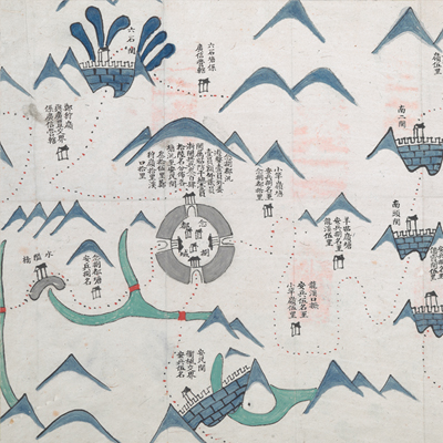
念捌都塘汛界址圖
Military Map of Nianbadu Battalion| Hanyu Pinyin | Nianbadu tang xun jie zhi tu |
|---|---|
| Date | Before the 13th year of Qing Yongzheng's reign, -1735. |
| Measurement | |
| Techniques | Ink and color manuscript |
| Material | paper |
| Quantity | |
| Categories | |
| Country of Repository | |
| Identifier | British Library |
| Link to Original Database | http://explore.bl.uk/primo_library/... |
| Notes | Add. MS. 16359 ( C) |
| Share |
No title appears on this map; the title applied here is based on content. Scale and legend are not given; annotation and orientation are written along the borders on all four sides with north at the right. Nianbadu is also known as Twenty-eighth Town. It was under the jurisdiction of Daocheng Township of Jiangshan County in Quzhou Prefecture, Zhejiang Province. It was located 200 li west of Suichang County, 120 li east of Guangfeng County, 120 li north of Pucheng County and 120 li south of the Jiangshan county seat; it was by the boundaries of Fujian and Zhejiang. Anmin, Liushi, and Xianxia are three important checkpoints between Zhejiang and Fujian. The map offers pictorial depictions of towns, checkpoints, military posts, bridges, and temples. Place names, military staffing levels, and mileages are annotated on the map. Nianbadu Battalion was under the jurisdiction of Founling Brigade. The map may have been drawn before the 13th year of Qing Yongzheng’s reign, 1735.
This map can be studied with the following maps in the National Palace Museum’s collection: Zhejiang Quzhou Fu dao li tu (map no. 021494); Zhejiang quan sheng dao li zong tu (map no. 021494); Zhejiang quan sheng dao li zong tu (map no. 021505-021506); Zhejiang quan sheng tu (map no. 021589); and the Library of Congress collection: Zheijiang quan tu (gm 71005029); Zhejiang yan hai yao kou quan tu (gm 2002626763); Qiantangjian yan an tu (gm 71005077).
This map can be studied with the following maps in the National Palace Museum’s collection: Zhejiang Quzhou Fu dao li tu (map no. 021494); Zhejiang quan sheng dao li zong tu (map no. 021494); Zhejiang quan sheng dao li zong tu (map no. 021505-021506); Zhejiang quan sheng tu (map no. 021589); and the Library of Congress collection: Zheijiang quan tu (gm 71005029); Zhejiang yan hai yao kou quan tu (gm 2002626763); Qiantangjian yan an tu (gm 71005077).