Military and Traffic Maps
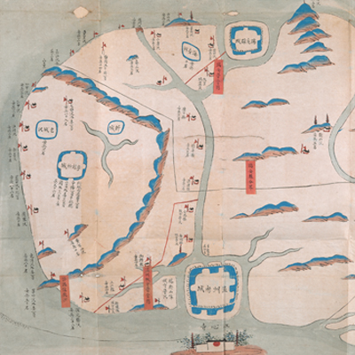
溫州鎮標右營陸汛輿圖
Military Map of Wenzhou Right Regiment| Hanyu Pinyin | Wenzhou Zhen Biaoyu Ying lu xun yu tu |
|---|---|
| Date | Between Qing Jiaqing and Daoguang period, 1800-1840. |
| Measurement | |
| Techniques | Ink and color manuscript |
| Material | paper |
| Quantity | |
| Categories | |
| Country of Repository | |
| Identifier | British Library |
| Notes | Or. 13159 (3) |
| Share |
The title is written on a red label affixed to the verso of the map. Scale and legend are not given; orientation is marked along the borders on all four sides with north at the bottom. The map covers the area from Ou River estuary in Wenzhou Prefecture in the north, to the south bank of the Anyang River in Rui’an County in the South. The map contains pictorial depictions of cities, military posts, mountains, islands and temples. All place names are annotated. Black lines form boundary markers with neighboring counties; red lines form boundary markers with neighboring battalions. Red labels are affixed to the lines for further description, such as “the most important and less important matter, soldiers increased and transferred; distance mileages are noted in the accompanying text.” Unfortunately the text is now lost.
The Right Regiment under Wenzhou Division was established in the 13th year of Qing Shunzhi’s reign, 1656. The map may have been drawn during Qing Jiaqing and Daoguang period, 1800-1840.
This map can be contrasted with the following maps in the National Palace Museum’s collection: Zhejiang Wenzhou Fu shu di li yu tu (map no. 020968); Zhejiang Wenzhou Fu shu di yu tu shuo (map no. 021312); Wenzhou Fu dao li tu (map no. 021496): Zhejiang quan sheng dao li zong tu (map no. 021505-021506); Zhejiang quan sheng tu (map no. 021589); and the Library of Congress collection: Zheijiang quan tu (gm 71005029); Zhejiang yan hai yao kou quan tu (gm 2002626763); Ning Jun di yu tu (gm 71002469); Qiantangjian yan an tu (gm 71005077); Jiang hai quan tu (gm 71005059).