Military and Traffic Maps
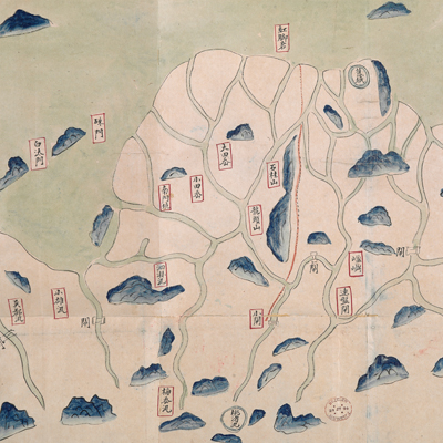
浙江台協營沿海各汛口岸洋圖
Military Map of Taizhou Brigade| Hanyu Pinyin | Zhejiang Taixie Ying yan hai ge xun kou an yang tu |
|---|---|
| Date | Qing Daoguang period, 1820-1843. |
| Measurement | |
| Techniques | Ink and color manuscript |
| Material | paper |
| Quantity | |
| Categories | |
| Country of Repository | |
| Identifier | British Library |
| Notes | Or. 13159 (2) |
| Share |
The title is written on a red label affixed to the verso of the map. Scale and legend are not given; orientation is marked along the borders on all four sides with north to the left. The map covers the territory under the jurisdiction of Taizhou Brigade along Taizhou Bay, west of Linhai County. The map includes pictorial depictions of bridges, river gates, and mountains. The information given is not complete; only a few battalions are annotated. This is an official military post map.
Taizhou is located in eastern Zhejiang, surrounded by mountains on three sides; one side faces the sea. The coast stretches for hundreds of li. Taizhou Brigade was established in the third year of Shunzhi’s reign, 1646, under the jurisdiction of Huangyan Division. The map may have been drawn during Daoguang period, 1820-1843.
This map can be contrasted with the following maps in the National Palace Museum’s collection: Zhejiang Taizhou Fu shu di yu tu shuo (map no. 020967); Zhejiang Taizhou Fu di yu tu shuo (map no. 021310); Zhejiang quan sheng tu (map no. 021589): Zhejiang quan sheng dao li zong tu (map no. 021505-021506); and the Library of Congress collection: Zheijiang quan tu (gm 71005029); Zhejiang yan hai yao kou quan tu (gm 2002626763); Ning Jun di yu tu (gm 71002469); Qiantangjian yan an tu (gm 71005077); Jiang hai quan tu (gm 71005059).