Military and Traffic Maps
浙江台協營沿海口岸圖
Military Map of Taizhou Brigade| Hanyu Pinyin | Zhejiang Taixie Ying yan hai kou an tu |
|---|---|
| Date | Qing Daoguang period, 1820-. |
| Measurement | |
| Techniques | Ink and color manuscript |
| Material | paper |
| Quantity | |
| Categories | |
| Country of Repository | |
| Identifier | British Library |
| Link to Original Database | http://explore.bl.uk/primo_library/... |
| Notes | Add. MS. 16358 (H) |
| Share |
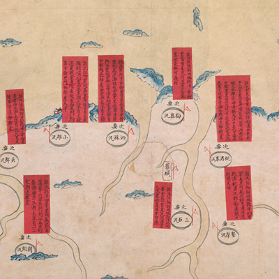
Title is missing; the title applied here is based on content. Scale and legend are not given; orientation is marked along the borders on all four sides with north at the left. The map covers Taixie Brigade’s jurisdiction along Taizhou Bay; from Haimen Xun in the south to Chikan Xun in the north, the same area of the coastline of the prefecture. Haimen Xun and Qiansuozhai Xun are respectively situated on the south and north sides of Taizhou Bay. Both are indicated with symbols of town and marked as the “most important” area. The remaining 10 military posts are marked as less important with oval shapes and affixed with a red label to record sea mileage, tides, water depths, and soft coating.
Taixie Brigade was established in the third year of Shunzhi’s reign, 1646, under the jurisdiction of Huangyan Division. Haimen Wei was directly under the jurisdiction of Huangyan Division’s Regional Commander (Zongbing); the rest were under the jurisdiction of Taizhou Brigade’s Regional Vice Commander (Fujiang). The map may have been drawn during Daoguang period, 1820.
This map can be contrasted with the following maps in the National Palace Museum’s collection: Zhejiang Taizhou Fu shu di li yu tu (map no. 020967); Zhejiang Taizhou Fu di yu tu shuo (map no. 020130); Zhejiang quan sheng dao li zong tu (map no. 021505-021506); Zhejiang quan sheng tu (map no. 021589); and the Library of Congress collection: Zheijiang quan tu (gm 71005029); Zhejiang yan hai yao kou quan tu (gm 2002626763); Ning Jun di yu tu (gm 71002469); Qiantangjian yan an tu (gm 71005077); Jiang hai quan tu (gm 71005059).