Military and Traffic Maps
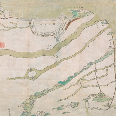
寧波府鎮海縣海口汛守圖
Seaport Map of Zhenhai County| Hanyu Pinyin | Ningbo Fu Zhenhai Xian hai kou xun shou tu |
|---|---|
| Date | After the second year of Qing Yongzheng's reign, 1724-. |
| Measurement | |
| Techniques | Ink and color manuscript |
| Material | paper |
| Quantity | |
| Categories | |
| Country of Repository | |
| Identifier | British Library |
| Link to Original Database | http://explore.bl.uk/primo_library/... |
| Notes | Maps 188.kk.1 (11) |
| Share |
Title is written on a yellow label affixed to the map’s verso. Scale and legend are not given; orientation is marked along the borders on all four sides with north at the top. The map contains pictorial depictions of cities, military posts, and bridge piers; place names are annotated. The Yin River is in the center of the map (also known as the Yong River), and it is known as the Dajia River in the Zhenhai County. The map covers the area from Ningbo to the East Sea; from the border of Yin County and Zhenhai County in the south to the Hangzhou Bay in the north; to the Songpu and Longshan military battalions in the west. The map covers administrative divisions within Zhenhai County.
Zhenhai Naval Brigade was established in 1646, under the jurisdiction of the Dinhai Division. All military posts under Longshan Suo in the west of Zhenhai County and the three battalions which became under the jurisdiction of Tibiaoqian Brigade in 1724 are marked on the map, but the Zhenhai battalion’s maritime jurisdiction are not yet present. The map may have been drawn after the second year of Qing Yongzheng’s reign, 1724.
This map can be contrasted with the following maps in the National Palace Museum’s collection: Zhejiang Ningbo Fu di yu tu shuo (map no. 020965); Zhejiang Ningbo Fu dao li tu (map no. 021491); Zhejiang Ningbo Fu shu di li yu tu (map no. 021510); Zhejiang Fujian yan hai hai fang tu (map no. 020869); Shimen Zhen bei di er zhan zhi Haining Xian Tangqi Zhen Daying dao li tu shuo (map no. 020819); Zhejiang Sheng hai tang tu (map no. 020880); Zhejiang Shaoxing Fu shu di li yu tu (map no. 020966); Zhejiang Shaoxing Fu di yu tu shuo (map no. 021309); Zhejiang Shaoxing Fu dao li tu (map no. 021492); Zhejiang Shaoxing Fu shu di tu (map no. 021520); and the Library of Congress collection: Zheijiang quan tu (gm 71005029); Zhejiang yan hai yao kou quan tu (gm 2002626763); Ning Jun di yu tu (gm 71002469); Qiantangjian yan an tu (gm 71005077); Jiang hai quan tu (gm 71005059).