Military and Traffic Maps
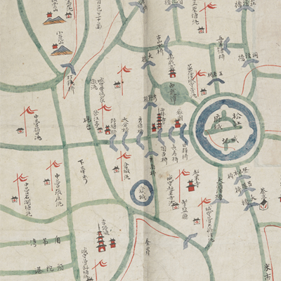
婁縣境輿圖
Map of Lou County| Hanyu Pinyin | Lou Xian jing yu tu |
|---|---|
| Date | Around the second year of Qing Tongzhi's reign, 1863. |
| Measurement | |
| Techniques | Ink and color manuscript |
| Material | paper |
| Quantity | |
| Categories | |
| Country of Repository | |
| Identifier | British Library |
| Notes | Or. 2338 (32) 4 |
| Share |
No title appears on the map; the title applied here is based on content. The name of Lou County is nowhere to be found on the map, but the area covered is the same territory of Lou County. The map depicts the area from Huating in the east to Qingpu County in the west; and it borders with Huangpu River, Pinghu County, and Jiashan County in Zhejiang in the south. Both Lou County and Huating County share the same capital town with Songjiang Prefecture. Scale and legend are not given. North is at the top. The hills, piers, temples, and rivers, flood control, military posts and banners are pictorially illustrated. All place names are annotated. Flags appear all over the map, and the seal of Ever Victorious Army of the British Parliament is on the verso. This is the combat map used by the British general Gordon (C. G. Gordon, 1833-1885). This is one of Charles George Gordon’s No. 32 collection.
This map can be contrasted with the following maps in the National Palace Museum’s collection: Changjiang di li tu (map no. 020878); Changjiang tu (map no. 020879); Jiangnan ge dao fu tu biao cun (map no. 020923-020941); Jiangnan quan sheng dao li zong tu (map no. 021560); Jiangsu hai fang tu (map no. 021513) and Ping ding yue fei zhan tu san shi jiu zhang (map no. 021283.001-021294.002); and the Library of Congress collection: Jiangsu quan tu (gm 71005111); Changjiang shui shi Guazhou Zhen Biaozhong Ying jiang xu quan tu (gm 80692824); Qing jun wei gong Jinling Cheng tu (gm 71005033).
This map can be contrasted with the following maps in the National Palace Museum’s collection: Changjiang di li tu (map no. 020878); Changjiang tu (map no. 020879); Jiangnan ge dao fu tu biao cun (map no. 020923-020941); Jiangnan quan sheng dao li zong tu (map no. 021560); Jiangsu hai fang tu (map no. 021513) and Ping ding yue fei zhan tu san shi jiu zhang (map no. 021283.001-021294.002); and the Library of Congress collection: Jiangsu quan tu (gm 71005111); Changjiang shui shi Guazhou Zhen Biaozhong Ying jiang xu quan tu (gm 80692824); Qing jun wei gong Jinling Cheng tu (gm 71005033).