Military and Traffic Maps
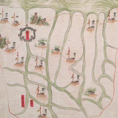
孟河營營汛全圖
Military Map of Menghe Brigade| Hanyu Pinyin | Menghe Ying ying xun quan tu |
|---|---|
| Date | Qing Daoguang period, 1821-1843. |
| Measurement | |
| Techniques | Ink and color manuscript |
| Material | paper |
| Quantity | |
| Categories | |
| Country of Repository | |
| Identifier | British Library |
| Link to Original Database | http://explore.bl.uk/primo_library/... |
| Notes | Add. MS. 16358 (O) |
| Share |
No title appears on this map; the title applied here is based on content. Scale, legend, and orientation are not given; but north is at the top, based on the brigade locations on the map. The map depicts some features pictorially, including military units and villages. Menghe Fort town is represented by town walls; the Yangtze River waterlines in the north are colored the usual dark green with a light sweep. There are several red labels with written text affixed to the map to note battalion troops and their control range but most labels have fallen off. There is explanatory text on the right to record Menghe Brigade’s military establishments and the names and distances the neighboring military units. This is the only map found in the atlas.
Menghe Brigade was situated in the Menghe Fort, and under the jurisdiction of Jiangnan Naval Corps Admiral. In 1868, Yangtze Navy was established and Menghe Brigade was one of the four brigades in charge of the river defense. The map may have been drawn around Qing Daoguang period, 1821-1843.
This map can be contrasted with the following maps in the National Palace Museum’s collection: Jiangnan ge dao fu tu biao cun (map no. 020923-41); Jiangnan tong sheng fu zhou xian yu di tu shuo (map no. 021297); Jiangsu hai fang tu (map no. 021513); and the Library of Congress collection: Jiangsu quan tu (gm 71005111); Changjiang shui shi Guazhou Zhen Biaozhong Ying jiang xu quan tu (gm 80692824); Menghe Ying hui cheng Bei Ying xun jing jiang cheng li shu jie zhi tu (gm 80692825).