Military and Traffic Maps
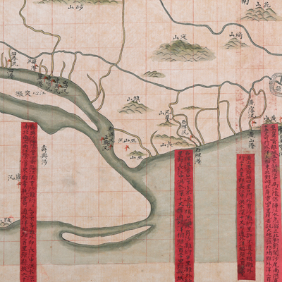
江陰縣沿江港汛圖
Map of the Coast Battalions in Jiangyin County| Hanyu Pinyin | Jiangyin Xian yan jiang gang xun tu |
|---|---|
| Date | Around the 20th year of Qing Daoguang's reign, 1840. |
| Measurement | |
| Techniques | Ink and color manuscript |
| Material | paper |
| Quantity | |
| Categories | |
| Country of Repository | |
| Identifier | British Library |
| Notes | Add. MS. 16360 (J) |
| Share |
Title is missing from the map; the title applied here is based on content. The Chinese scale was given as “each grid represents 3 li” (approximately 1 mile). Legend is not given; orientation is marked along the borders on all four sides with north at the bottom. The map depicts the capital town of Jiangyin County and mountains pictorially. The rivers and waterways are colored in dark green. The map covers 84 li of flood embankments along the river from Jiangwu in the west to Changshu in the east. Twelve red labels affixed to the map record distances from ports to the county town, the beach length, distance to the ocean, and water depth of the Yangtze River.
Jiangyin was under the jurisdiction of Changzhou Prefecture. This is an administrative map with emphasis on port locations and flood embankment distribution. Based on the “install emplacements” instructions given at several places on the map, the map may have been drawn around the 20th year of the Qing Daoguang’s reign, 1840.
This map can be studied with the following maps in the National Palace Museum’s collection: Jiangsu hai fang tu (map no. 021513); Baoshan Xian hai tang tu (Grand Council file no. 046243-a); Ge sheng yan hai kou ai quan tu (map no. 020867); Yan hai chang tu (map no. 020868); Jiangnan ge dao fu tu biao cun (map no. 020923-020941); and the Library of Congress collection: Jiang hai quan tu (gm 71005059); Qi sheng yan hai quan tu (gm 71005064); Hai jiang yang jie xing shi tu (gm 71005021); Nan bei yang he tu (gm 71005215); Beiyang fen tu (gm 71005226); Huanghe nan he tu (gm 71005024).