Military and Traffic Maps
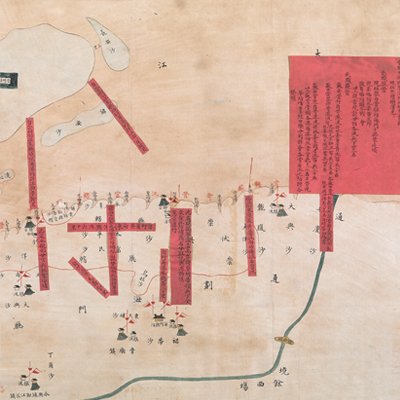
海門闔境各港分界全圖
Military Map of Haimen Sub-prefecture| Hanyu Pinyin | Haimen he jing ge gang fen jie quan tu |
|---|---|
| Date | The 20th-22nd year of Qing Daoguang's reign, 1840-1842. |
| Measurement | |
| Techniques | Ink and color manuscript |
| Material | paper |
| Quantity | |
| Categories | |
| Country of Repository | |
| Identifier | British Library |
| Link to Original Database | http://explore.bl.uk/primo_library/... |
| Notes | Add. MS. 16359 (Q) |
| Share |
Title is written at the top right. Scale and legend are not given; orientation is marked along the borders on all four sides with north at the bottom. The map depicts some features of Haimen sub-prefecture with simple images, including military units.
There are 12 red labels with written text affixed to the map to record military stations, and the number of soldiers in each post, nautical mileage, and government officials. This is part of a set with another map in the British Library titled “Map of Measuring the Depth of Water Potential of Each Port in Haimen Sub-prefecture” (Add MS. 16359 (P)). Based on the information written on the red labels, both maps may have been drawn around the 20th to the 22nd year of Qing Daoguang’s reign, 1840-1842.
This map can be contrasted with the following maps in the National Palace Museum’s collection: Jiangnan tong sheng fu zhou xian yu di tu shuo (map no. 021297); Zhang kan Tongzhou Chongming Zhaowen san zhou xian sha di zong tu (map no. 021428); Jiangsu hai fang tu (map no. 021513); and the Library of Congress collection: Jiang hai quan tu (gm 71005059); Qi sheng yan hai quan tu (gm 71005064); Hai jiang yang jie xing shi tu (gm 71005021); Nan bei yang he tu (gm 71005215); Beiyang fen tu (gm 71005226); Huanghe nan he tu (gm 71005024).