Military and Traffic Maps
通州江海輿圖
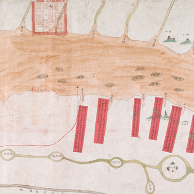
Coastal Map of Tongzhou| Hanyu Pinyin | Tongzhou jiang hai yu tu |
|---|---|
| Date | Around the 20th year of Qing Daoguang's reign, 1840. |
| Measurement | |
| Techniques | Ink and color manuscript |
| Material | paper |
| Quantity | |
| Categories | |
| Country of Repository | |
| Identifier | British Library |
| Link to Original Database | http://explore.bl.uk/primo_library/... |
| Notes | Add. MS. 16358 (M) |
| Share |
Title is written on a label in black ink and affixed to the map. Scale and legend are not given; orientation is written along the borders on three places with north at the bottom. The map offers pictorial depictions of the cities, government offices, temples, mountains, and rivers of the Yangtze River Delta near Tongzhou. Different colors are used to distinguish the Yangtze River and the ocean. Annotations mark fresh water and salty water. There are 15 red labels to identify the water depths with tides, shoals, reefs, and ocean mileages. The official Tongzhou seal is stamped on the upper right.
Tongzhou was originally under the jurisdiction of Yangzhou Prefecture; later it became a municipality in second year of Qing Yongzheng’s reign, 1724. Tongzhou is situated at a strategically important location where river and sea meet and surrounded by islands. It is an important coastal defense municipality on the northern side of Yangtze River. The map shows military units and foreign boats and was made for military purpose. The map may have been drawn around the 20th year of Qing Daoguang’s reign, 1840.
This map can be studied with the following document and maps in the National Palace Museum’s collection: Jiangnan tong sheng fu zhou xian yu di tu shuo (map no. 021297); Zhang kan Tongzhou Chongming Zhaowen san zhou xian sha di zong tu (map no. 021428); Jiangsu hai fang tu (map no. 021513); and the Library of Congress collection: Jiang hai quan tu (gm 71005059); Qi sheng yan hai quan tu (gm 71005064); Hai jiang yang jie xing shi tu (gm 71005021); Nan bei yang he tu (gm 71005215); Beiyang fen tu (gm 71005226); Huanghe nan he tu (gm 71005024).