Military and Traffic Maps
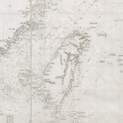
大清一統海道總圖
General Map of the Chinese Coast and Sea-routes| Hanyu Pinyin | Da Qing yi tong hai dao zong tu |
|---|---|
| Date | After the 13th year of Qing Tongzhi's reign, 1874-. |
| Measurement | |
| Techniques | Stone rubbing |
| Material | paper |
| Quantity | |
| Categories | |
| Country of Repository | |
| Identifier | British Library |
| Link to Original Database | http://explore.bl.uk/primo_library/... |
| Notes | Maps 62655 (3) |
| Share |
Title is written on the left. Legend is not given; scale and orientation are indicated along the borders on all four sides with north at the top. The map also includes several engraving compass directions; it is a fairly accurate coastal map. The map covers the latitude from 21°30’ N to 41°06’ N, and longitude, with the center line running through Beijing, from 3°55’ W to 11°15’ E. The area covers from south at Shito Bay in Shangchuan Island of Guangzhou Prefecture to north at Yalu River estuary near the border between Korea and China. The map also depicts the coastline of Korea in detail. Affiliated islands in the coastal waters are also shown, including Taiwan and surrounding islands. The map records coastal hydrology, shoals, and coordinates carvings, varied water depths during high and low tides in detail. Annotation in the vicinity of Taiwan and surrounding islands explains the depths of Taiwan shoal, overlapping waves and their shades. Obviously there was a great deal of knowledge of Taiwan at the time to make such a refined and detailed hydrographic map.
Names of coastal places and islands on the map are different from the customary names. For example, Tu Islands (i.e. Huaping Island); Gelaige Island (i.e. Meihua Island); Aijinkeerte Island (i.e. Pengjishan); Tuliedao (Ganlan Mountain, or Xuepolan); Heping Mountain (i.e. Diaoyu Island, British mistook it as Huaping Island; Diyawusu Island (i.e. Huangwei Island, British mistook it as Diaoyu Island); Elelishi (i.e. Chiwei Island); Poduiertubage Island (i.e. Green Island). The English translated names were adopted from British John Fryer’s (1839-1928) interpretation. The map may have been drawn after the 13th year of Qing Tongzhi’s reign, 1874.
This map can be contrasted with the following maps in the National Palace Museum’s collection: Beiyang hai an tu (map no. 021554); Xun yue Bei yang hai fang tu (map no. 021555); Bohai yan an dao li tu (map no. 021471); Fengtian Sheng tu (map no. 021489); Deng, Jin, Shan, Ning si zhen hai tu (map no. 021455); and the Library of Congress collection: Jiang hai quan tu (gm 71005059); Qi sheng yan hai quan tu (gm 71005064); Hai jiang yang jie xing shi tu (gm 71005021); Shandong Zhili Shengjing hai jiang tu (gm 71005062); Nan bei yang he tu (gm 71005215); Nan yang fen tu (gm 71005139); Bei yang fen tu (gm 71005226).