Flood Control and Embankment Maps
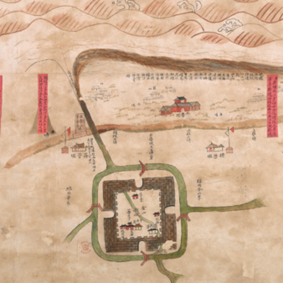
金山縣會勘海塘圖
Map of the Sea-embankment of Jinshan County| Hanyu Pinyin | Jinshan Xian hui kan hai tang tu |
|---|---|
| Date | The 18th - 23rd year of Qing Daoguang's reign, 1838-1843. |
| Measurement | |
| Techniques | Ink and color manuscript |
| Material | paper |
| Quantity | |
| Categories | |
| Country of Repository | |
| Identifier | British Library |
| Link to Original Database | http://explore.bl.uk/primo_library/... |
| Notes | Add. MS. 16360 (G) |
| Share |
Title is written in black ink on a red label. No scale or legend is given; orientation is marked along the borders on all four sides with north at the top. The map depicts the waves, ripples, fortresses, temples, military platoons, sand embankments, salt fields, and ash disposal sites. Another four red labels are attached to the map to indicate the ownerships of each sand dam segments, and the distance between the fortress and mudflats and seawalls. The map covers the area from the west of Jinshan, Songjiang Prefecture to the seawalls of Pinghu County, Zhejiang Province; place names and boundaries are annotated on the map. One particular sand dam is colored darker and accompanied with explanatory texts of the dam destroyed by floods in the 48th year of Qianlong’s reign, 1783. This was an official seawall project map. Based on the depiction and annotation of the increased thickness of the seawall slope, the map may have been drawn during the 18th to the 23rd year of Qing Daoguang’s reign, 1838-1843.
This map can be contrasted with the following maps in the National Palace Museum’s collection: Jiangsu hai fang tu (map no. 021513); Baoshan Xian hai tang tu (grand council file no. 046243-a); Ge sheng yan hai kou ai quan tu (map no. 020867); Yan hai an chang tu (map no. 020868); Jiangnan ge dao fu tu biao cun (map no.020923-020941); and the Library of Congress collection: Su nan hai tang tu (gm 71005013); Jiang hai quan tu (gm 71005059); Qiantangjian yan an tu (gm 71005077).
This map can be contrasted with the following maps in the National Palace Museum’s collection: Jiangsu hai fang tu (map no. 021513); Baoshan Xian hai tang tu (grand council file no. 046243-a); Ge sheng yan hai kou ai quan tu (map no. 020867); Yan hai an chang tu (map no. 020868); Jiangnan ge dao fu tu biao cun (map no.020923-020941); and the Library of Congress collection: Su nan hai tang tu (gm 71005013); Jiang hai quan tu (gm 71005059); Qiantangjian yan an tu (gm 71005077).