Maps of Social and Economic Conditions
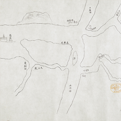
廣州至澳門水道圖
Map of the Waterways between Canton and Macao| Hanyu Pinyin | Guangzhou zhi Aomen shui dao tu |
|---|---|
| Date | After the 14th year of Qing Jiaqing's reign, 1809. |
| Measurement | |
| Techniques | Pen-and-ink manuscript on paper |
| Material | paper |
| Quantity | |
| Categories | |
| Country of Repository | |
| Identifier | British Library |
| Notes | Or. 2342 B; Or. 2342 C |
| Share |
No title appears on this map; the title applied here is based on content. The map consists of two sheets. There is no expressed scale. Orientation depends on perspective since maps can be viewed from either the top or the bottom. The legend on one map (Or. 2342 C) is depicted pictorially on the left while 32 place names are indicated on the right with distances between places penciled in. temples, mountains, and military units are illustrated pictorially and place names are indicated with text.
The other map (Or. 2342 B) depict the inland waterways between the Pearl River estuaries to Haoketou of the Fragrant Hills outside Canton. The end of the map depicts the terrain from Diyijiao to Haoketou. Haoketou was an important military garrison station. The maps cover the territory inside Xiangshan County, but the mileage to Macao was recorded only on one map (Or. 2342 C). The maps illustrated the waterways between Canton and Macao and military installations along the way. Comparing with another similar map included in the section of military maps in this book (see map Or. 7409 B), it is clear that the map may have been drawn after the 14th year of Jiaqing’s reign, 1809.
This map can be contrasted with the following maps in the National Palace Museum’s collection: Guangdong Sheng shu ge zhou fu xian di yu tu shuo (map no. 021157); Guangdong Sheng di tu (map no. 021477); Guangdong zhi Xianluo shui lu dao li tu (Grand Council file no. 010186); and the Library of Congress collection: Guangdong quan tu (gm 71005120); Guangdong tong sheng shui dao tu (gm 71002467); Guangdong quan sheng shui lu yu tu (gm 71005159).