Maps of Social and Economic Conditions
兩淮鹽河圖
Map of the Salt-transport Canals in Jiangsu Province| Hanyu Pinyin | Liang Huai yan he tu |
|---|---|
| Date | Around the 22nd year of Qing Qianlong's reign, 1757. |
| Measurement | |
| Techniques | Ink and color manuscript |
| Material | paper |
| Quantity | |
| Categories | |
| Country of Repository | |
| Identifier | British Library |
| Link to Original Database | http://explore.bl.uk/primo_library/... |
| Notes | Add. MS. 16359 (L) |
| Share |
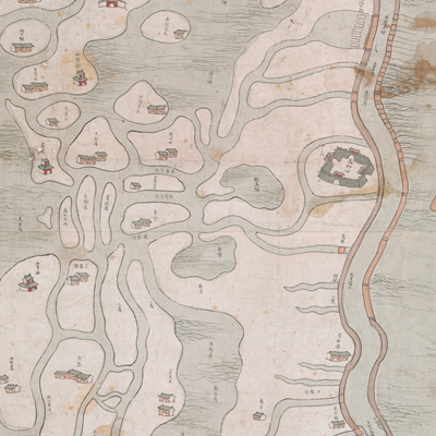
No title appears on the map; the title applied here is based on content. Part of the map is missing; the remaining map covers the areas from the Grand Canal to Taizhou and Xinghua in the east, the south of Taizhou’s salt-transport canal in the west and Huai’an Prefecture in the north. The majority of areas covered were under the jurisdiction of Yangzhou and Huai’an Prefectures.
No scale or legend is given; north is at the bottom. The map was pictorially drawn with illustrations of prefectures, counties, mountains, temples, villages, and settlements. The Grand Canal was depicted in a prominent fashion. Seven explanatory notes were written near the Grand Canal, Xinghua County, and Yangmao Bay on the map. The notes contain more detailed information about salt smuggling routes and government counter measures. This official map was used for anti-smuggling purposes. The map is incomplete; the missing part is most likely of Huai’an area. The Huai Yang region is the Huai Slat area in Hunan, Hubei, and Jiangxi provinces, also known as Huaiji. Almost half of the Qing Dynasty’s salt tariff was from this region. But the official salt sale was only about half of the output because most of the salt produced was sold outside of official channels.
In the ninth year of Tongzhi’s reign, 1870, the Salt Commissioner wrote to the emperor and explained the reason for lower salt prices. In order to avoid tax and shipping, Huaije became the local distribution center for salt smuggling. However the issue of private salt sales was never resolved. Both South and North Huai region was the largest unofficial salt distribution center since the Ming and Qing Dynasties. Judging from events and projects along the Grand Canal, the map may have been drawn around the 22th year of Qing Qianlong’s reign, 1757.
This map can be contrasted with the following maps in the National Palace Museum’s collection: Huang Huai he tu (map no. 020874); Huaihe tu (map no. 020875-020876); Huang Yunhe gong cheng tu (map no. 020891-020190); Jiang, Gan, Tai san zhou xian shu Jinwanzha xia zhi Taizhou tian chi ying jun yun yan he dao he tu (Grand Council document no. 018026); Chou kai Huaibei xin yan he qing xing tu (Grand Council document no. 038723); and the Library of Congress collection: Liang Huai yan chang ji si sheng xing yan tu (gm 71005050).