Military and Traffic Maps
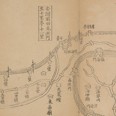
安瀾園至尖山起座道里圖說:第三站
Illustrated map of the Emperor's travel route| Hanyu Pinyin | Anlanyuan zhi Jianshan qi zuo dao li tu shuo: di san zhan |
|---|---|
| Creator | Anonymous |
| Date | Qing Qianlong period, 1765-1780 |
| Measurement | |
| Techniques | Woodcut |
| Material | paper |
| Quantity | |
| Categories | |
| Country of Repository | |
| Identifier | Library of Congress |
| Link to Original Database | http://lccn.loc.gov/85693767 |
| Acquisition Date | 19647月 |
| Share |
The map is folded and opens from right to left. The map covers the travel route from Anlanyuan of Haining Department in Zhejiang Province, passing by Haishen temple and Chunximen to Zhenhai Tower. The accompanying notes at the end of map give the distances between cities and roads; the notes also explain the Haitang Renovation Project and the work to strengthen the tide gate dam. The map describes roads, villages, castles, bridges, as well as palaces and altars in the mountains of Jianshan and Tashan. Orientation and scale were not utilized for this map.
Qing Emperor Qianlong ordered a renovation of the seawall embankment in Jiangsu and Zhejiang in 1765 on his fourth inspection trip to the south. Therefore, it can be assumed that the map was prepared for the Emperor between his fourth and fifth trip to the south (1765-1780).
This map can be studied with the following maps in the National Palace Museum's collection: title: Qianlong nan xun ji cheng tu (map no. 020803-020818); title: Shimen Zhen bei di er zhan zhi Haining Xian Tangqi Zhen Daying dao li tu shuo (map no. 020819); title: Tangqi Zhen di san zhan zhi sheng cheng nei xing gong dao li tu shuo (map no. 020820); title: Haining Chenyuan di si zhan zhi sheng cheng nei xing gong dao li tu shuo (map no. 020821); title: Qianlong si shi wu nian gong feng huang shang nan xun jing you Zhili dao lu tu shuo (Grand
council document no. 022503).