Military and Traffic Maps
太平府境全圖
Complete Map of Taiping Prefecture| Hanyu Pinyin | Taiping Fu jing quan tu |
|---|---|
| Creator | Anonymous |
| Date | Qing Guangxu period, -1887 |
| Measurement | |
| Techniques | Ink and color manuscript |
| Quantity | |
| Categories | |
| Country of Repository | |
| Identifier | Library of Congress |
| Link to Original Database | http://lccn.loc.gov/84696160 |
| Share |
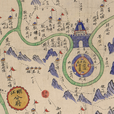
No title appears on the map; the title applied here is based on content. Liangshan, a Vietnamese provincial capital, is on the bottom left. This is a typical Qing Dynasty provincial military map. The map depicts the Green Standard Army stations and forts along the Sino-Vietnam borders in Taiping Prefecture, Guangxi
Province. The mountains, rivers, roads, cities, and checkpoints are shown pictorially. The dotted lines represent roads that also list distance; different colors indicate different types of roads; the castle in the center represents the headquarters of the garrison troops; small red flags with little houses stand for garrison stations; red flags with green tassels at the bottom left signify the Zhennan Pass, the most important military pass on the southern border where Chinese forces defeated the French army in March, 1885. The map was most likely drawn after the battle when more soldiers and forts were added.
The map can be studied with the following map in the National Palace Museum's collection: title: Guangxi Sheng di tu (map no. 021516).