Flood Control and Embankment Maps
江南海塘圖
Map of southern Jiangsu Seawall| Hanyu Pinyin | Jiang nan hai tang tu |
|---|---|
| Creator | Anonymous |
| Date | Qing Qianlong period, 1750-1753 |
| Measurement | |
| Techniques | Ink and color manuscript |
| Material | paper |
| Quantity | |
| Categories | |
| Country of Repository | |
| Identifier | Library of Congress |
| Link to Original Database | http://lccn.loc.gov/gm71005013 |
| Acquisition Source | Hummel, Arthur William, 1884-1975 |
| Acquisition Method | |
| Acquisition Date | 1934 |
| Share |
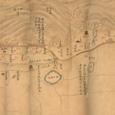
The map expands from right to left with north to the left. The map starts from right at Dushan, Zhejiang Province and ends left at the junction of Taicangzhou and Zhaowen County. The coastline extends north, without regard to the actual orientation on the map.
The map depicts the seawall renovation project in Songjiang Prefecture. City walls, checkpoints, and beacon towers are shown pictorially with symbols of houses and flagpoles; the sea in waves, clay embankments in brown; and stone embankments in stacked stones. The map also shows temples, forts, and flood control dams.
Text annotations recorded each county's seawall construction works, start and end dates, origin and destination, length, and other important notes. Marginal notes along the Huangpu River and the Qiujiang River read “In the 13th Year of Qing Qianlong Reign (1748), the emperor appropriated funds to fortify embankments. Workers were mobilized to move soil from the Qiujiang River to the mouth of Huxiang along the south bank dikes, the total length is 3,290 zhang (approximately 6 1/2 miles)”; this is the only date mentioned on the map. The date for the map is believed to be from 1750 to 1753. Title is added based on the map's content.
The map can be studied with the following maps in the National Palace Museum's collection: title: Jiangsu Nan He tu (map no. 021501); title: Jiangsu hai fang tu (map no. 021513) .