Flood Control and Embankment Maps
銅瓦廂至海口新黃河河道隄工形勢圖
Map of the embankment project of the new lower reaches of the Yellow River| Hanyu Pinyin | Tongwaxiang zhi hai kou xin Huang He he dao di gong xing shi tu |
|---|---|
| Creator | Anonymous |
| Date | Late Qing period, 1884 |
| Measurement | |
| Techniques | Ink and color manuscript |
| Material | paper |
| Quantity | |
| Categories | |
| Country of Repository | |
| Identifier | Library of Congress |
| Link to Original Database | http://lccn.loc.gov/gm71002473 |
| Acquisition Source | Hummel, Arthur William, 1884-1975 |
| Acquisition Method | |
| Acquisition Date | 1962 |
| Share |
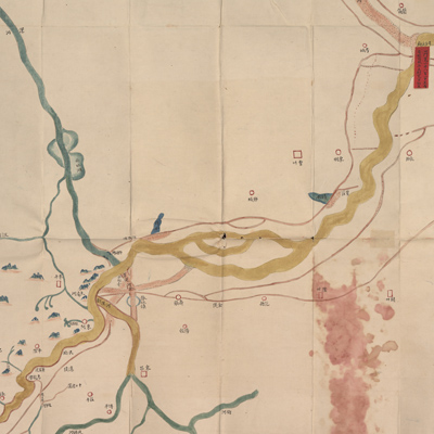
No title appears on the map; the title applied here is based on content. Notes in the margins indicate orientation; north is on the bottom. The map depicts the location in Tongwaxiang where a dam burst on the east bank of the Yellow River in Henan Province. In 1855 (the 5th Year of Qing Xianfeng Reign) unusual rainfalls upstream caused massive breeching of levies in Shandong Province, diverting the river into a new, more northern trajectory and merging with the Grand Canal to enter the sea. The map covers the affected areas from Tongwaxiang in Lanyi County, Henan Province on the right to the Yellow River estuary on the left. The river divided into two watercourses in Qihe County; the two map sheets depict the upper and lower watercourses respectively. Each map illustrates watercourse engineering projects, with emphasis on various conditions of the new Yellow River watercourse: main stream, distributaries, flooding path, andconstruction of dikes and fascines; the map also describes the old and new routes of the Grand Canal after the Yellow River passes through here.
Different symbols are used to indicate the location of prefectures, sub-prefectures, and counties. Different colors are applied to distinguish one from the other: the Yellow River is depicted in double yellow lines; distributaries in light brown blocks; the Grand Canal and other rivers in blue; embankments in dark brown lines; embankment fortifications and river blockage sites are recorded on red labels. Zhangqiu Township in Yanggu County is indicated as the “Old Canal”; the "new canal" is marked near Taochengfu.
The map can be studied with the following maps in the National Palace Museum's collection: title: Yi kao nan bei liang an di ba ge gong qing xing (Grand Council file no. 030159-1); title: Bei an si ting gong cheng zong he tu (map no. 020890).