Flood Control and Embankment Maps
蘭、儀、睢三廳河道起止里數工程段落丈尺總河圖
Map of the Southern Embankment of Yellow River in Henan Province| Hanyu Pinyin | Lan, Yi, Sui san ting Guangxu er nian fen he dao |
|---|---|
| Creator | Anonymous |
| Date | Mid-Qing period, -1855 |
| Measurement | |
| Techniques | Ink and color manuscript |
| Material | paper |
| Quantity | |
| Categories | |
| Country of Repository | |
| Identifier | Library of Congress |
| Link to Original Database | http://lccn.loc.gov/80692838 |
| Acquisition Source | Hummel, Arthur William, 1884-1975 |
| Acquisition Method | |
| Acquisition Date | 1962 |
| Share |
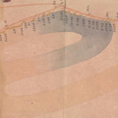
The map expands from right to left. Notes in the margins indicate orientation; north is on the bottom. The Yellow River flows upstream to downstream, from west to east. The map starts at the junction area of Lanyiting and Yisuiting and ends at the junction area of Yisuiting and Suiningting. The map depicts various types of embankments on the south bank and sites the Yellow River passes through. There are no red label annotations attached. This is a map of the Yellow River embankment fascine works.
The map can be studied with the following maps in the National Palace Museum's collection: title: Bei an si ting gong cheng zong he tu (map no. 020890); title: Lanyang bei an Tongwaxiang gong zhuo fang shui xiang xing tu (Grand Council file no. 040879); title: Yi kao nan bei liang an di ba ge gong qing xing (Grand Council file no. 030159-1); title: Suining Xiang Huang He nan an zhou jia lou di gong man yi qing xing tu (Grand Council file no. 040923); title: Lanyang bei an shui shi gong cheng tu (Grand Council file no. 009463); title: Chou ban Zhoujialou man kou guo tou bing tiao shui ju yin qu qing xing tu (Grand Council file no. 041004); title: Lanyi Xian Huang He gong cheng tu (Grand Council file no. 138485); title: Yu Sheng xing he xian zailiu shi qing xing tu (Grand Council file no. 034347) ; title: Yi kao er xun man gong cao tu (Grand Council file no. 022802-1) ; title: Xin he fen liu pang zhu bing qiang xiang shao gong qing xing tu (Grand Council file no. 033650).
The map can be studied with the following maps in the National Palace Museum's collection: title: Bei an si ting gong cheng zong he tu (map no. 020890); title: Lanyang bei an Tongwaxiang gong zhuo fang shui xiang xing tu (Grand Council file no. 040879); title: Yi kao nan bei liang an di ba ge gong qing xing (Grand Council file no. 030159-1); title: Suining Xiang Huang He nan an zhou jia lou di gong man yi qing xing tu (Grand Council file no. 040923); title: Lanyang bei an shui shi gong cheng tu (Grand Council file no. 009463); title: Chou ban Zhoujialou man kou guo tou bing tiao shui ju yin qu qing xing tu (Grand Council file no. 041004); title: Lanyi Xian Huang He gong cheng tu (Grand Council file no. 138485); title: Yu Sheng xing he xian zailiu shi qing xing tu (Grand Council file no. 034347) ; title: Yi kao er xun man gong cao tu (Grand Council file no. 022802-1) ; title: Xin he fen liu pang zhu bing qiang xiang shao gong qing xing tu (Grand Council file no. 033650).