Flood Control and Embankment Maps
黃河南河圖
Map of the lower reaches of the Yellow River| Hanyu Pinyin | Huanghe nan he tu |
|---|---|
| Creator | Anonymous |
| Date | The 15th Year of Qing Qianlong Reign, 1750 |
| Measurement | |
| Techniques | Ink and color manuscript |
| Material | silk |
| Quantity | |
| Categories | |
| Country of Repository | |
| Identifier | Library of Congress |
| Link to Original Database | http://lccn.loc.gov/gm71005024 |
| Acquisition Source | Hummel, Arthur William, 1884-1975 |
| Acquisition Method | |
| Acquisition Date | 1930 |
| Share |
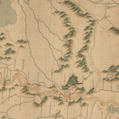
The map is oriented with north on the bottom. The Yellow River flows from upstream to downstream with its right bank on top. The map expands from right to left. It covers the area from Dangshan County, the very northern part of Anhui Province, and the junction of Anhui, Jiangsu, Shandong, and Henan Province to Yuntiguan, the estuary of the Yellow River in the north of Jiangsu Province. This section was called Nan He under the jurisdiction of the Nan He governor during the Qing Dynasty. After the Yellow River merged with the Huai River to enter the sea, most flood damage occurred at this section during the Ming and Qing
dynasties. In the 16th Year of Qing Kangxi Reign (1677), Jin Fu (1633-1692, style name Ziyuan) was named superintendent of the River Department. The River Department was set up in Qingjiangpu, not far from several rivers and canals. In the 7th Year of Qing Yongzheng Reign (1729), the Governor of the South River (referred to as the Nan He Governor) was formally established
and stationed in Qingjiangpu.
The map depicts the river system within the lower reaches of the Yellow River, the canal, and the surrounding rivers. All of the river engineering projects are fully indicated and annotated with projects names. The map also describes mountains, rivers, cities, embankments, and gate bridges; however, the symbols used for the shape of mountains are not consistent. The Yellow River and the Grand Canal are shown in yellow and blue respectively, embankments in brown.
The map can be studied with the following maps in the National Palace Museum's collection: title: Jiangsu Nan He tu (map no. 022501); title: Huang He tu (map no. 020870); title: Jiangnan Sheng Yun He ge ting shu he dao zha ba gong cheng qing xing tu (map no. 020911); title: Jiangnan Sheng Yunhe di shao zha ba gong cheng zong tu (map no. 020913); title: Jiangnan Honghe yi dai qing xing tu (Grand Council file no. 045112-a); title: Taozhuang xin he tu (Grand Council file no. 040555-a); title: Taozhuang xin hexing shi tu (Grand Council file no. 040792); title: Huanghe Qinghe mu long tu (map no. 020888).