Flood Control and Embankment Maps
黃、運、湖、河全圖
Complete map of the Yellow River, the Grand Canal, Hongze Lake, and the Huai River| Hanyu Pinyin | Huang, Yun, Hu, He quan tu |
|---|---|
| Creator | Sazai; Gao Jin |
| Date | Qing Qianlong period, 1777-1780 |
| Measurement | |
| Techniques | Ink and color manuscript |
| Material | silk |
| Quantity | |
| Categories | |
| Country of Repository | |
| Identifier | Library of Congress |
| Link to Original Database | http://lccn.loc.gov/gm71005017 |
| Acquisition Source | Hummel, Arthur William, 1884-1975 |
| Acquisition Method | |
| Acquisition Date | 1930 |
| Share |
This set consists of five maps.
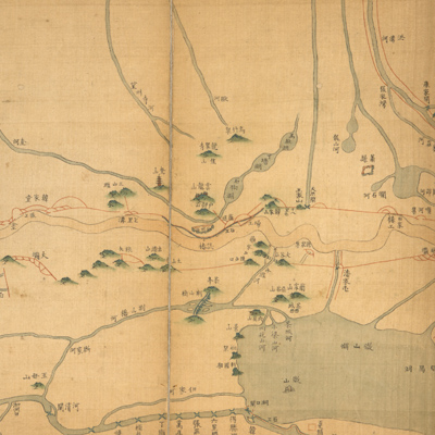
“Huang, Yun, Hu, He quan tu” (Complete map of the Yellow River, the Grand Canal, Hongze Lake, and the Huai River): the map starts at the border of Henan and Shangdong Province in the west, to the east of Mount Dadu and Huangnizha area that is surrounded by the Yellow River, the Grand Canal, the Huai River, and the Hongze Lake. The map depicts mountains, river systems, towns, buildings, embankments, and bridges. The report submitted to the emperor by the governor Sazai (? -1786) described the Yellow River and the Grand Canal after diverting water to the new Taozhang River in the 45th Year of Qing Qianlong Reign (1780). The map can be studied with the following reports in the National Palace Museum's collection: title: Zou wei gong bao Taozhuang Xinhe zhan kian gong jun yan shou yuan you (Grand Council file no. 026921); title: Taozhuang Xinhe gu tiao zhan kuan tu (Grand Council file no. 026369).
“Yi jian dong, xi ba tu” (Map of relocated east and west embankments): north is on the bottom. The map depicts Hongze Lake, the Huai River, the junction of Qingkou and the Yellow River estuary, and the newly relocated east and west embankments. The notes also explain the reason for recommending the relocation. The map can be studied with the following memorial reports in the National Palace Museum's collection: title: Zou wei Qingkou Xinxiba yi xia xin zhu shu shui di gong zan zhu wan jun, the 44th Year of Qing Qianlong Reign; and title: Qingkou Xinxiba yi xia xin zhu shu shui di gong tu (Grand Council file no. 022971).
“Taozhuang Xinhe bin lan Huang Shunhuangba tu” (Map of barrier and gravity dams on the new Yellow River in Taozhuang): north is on the bottom. The map depicts the fascine construction and fortification along the Yellow River and New River in Taozhuang, Qinghe County. The accompanying text also explains the reason for recommending the relocation. The map can be studied with the following reports in the National Palace Museum's collection: title: Taozhuang Xinhe tu, the 42nd Year of Qing Qianlong Reign (Grand Council file no. 040555-a); title: Taozhuang xin he xing shi tu (Grand Council file no. 040792); title: Zou wei cha kan Taozhuang xin he shang xia qing xing qing tian zha mu long yuan you (Grand Council file no. 403031899).
“Wucheng Sanbao tu” (Map of Sanbao in Wu city): north is on the bottom. The map depicts the newly built yellow-brick embankment and fortification at Sanbao on the Yellow River's south bank and includes the application for the embankment project submitted by governor Sazai and the Yellow River governor Gao Jin to the emperor. This map can be studied with the following reports in the National Palace Museum's collection: title: Gaojiazhai ji Suizhouxiaxun Sanbao ni jian tiao shui tub a qing xing tu, the 42th Year of Qing Qianlong Reign (Grand Council file no. 040031); title: Taozhuang xin he xing shi tu (Grand Council file no. 040792). “Haikou bing Ertao tu” (Map of Ertao and the mouth of the Yellow River): north is on the bottom. The map depicts the Yellow River's watercourse from Yuntiguan to the estuary and includes the application for the embankment construction at Ertao. Also the map can be studied with the following memorial reports in the National Palace Museum's collection: title: Zou bao Yuntiguan wao wai zuo yu jiu yan zhao jiu tian bu qing xing” and “Yundi wai Santao yan man yu qing xing tu” (Grand Council file no. 024131).