Mixed-theme Maps
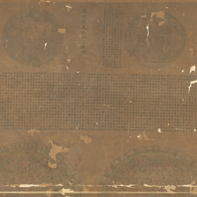
大清統屬職貢萬國經緯地球式
The Great Qing Dynasty world map of tribute bearing countries with spherical coordinates, past and present| Hanyu Pinyin | Da Qing tong shu zhi gong wan guo jing wei di qiu shi |
|---|---|
| Creator | Zhuang Tingfu |
| Date | The 59th Year of Qing Qianlong Reign, 1794 |
| Measurement | |
| Techniques | Ink and color manuscript |
| Material | silk |
| Quantity | |
| Categories | |
| Country of Repository | |
| Identifier | Library of Congress |
| Link to Original Database | http://lccn.loc.gov/gm71005053 |
| Share |
The map combines the mapping style and explanatory text of three different maps: “Official complete map of mountains and seas”; “Record of things seen and heard in the maritime countries”; and “The Great Qing Dynasty world map of tribute-bearing countries with spherical coordinates.” During the early Qing Dynasty, Western missionaries in China influenced some Chinese intellectuals by blending traditional Chinese mapping skills with Western knowledge of the world. This map provides ample evidence of this trend by combining Western coordinates with the Chinese traditional calendar of twenty-four seasons. The map was probably based on the “Illustrated discussion of the tribute-bearing countries” made in 1794, and combined with a compilation of spherical world maps made by the Western missionaries.
The Western missionary map can be studied with the following maps in the National Palace Museum's collection: title: Kun yu quan tu (map no. 020786-020793); title: Da di quan qiu yi lan tu; (exhibition no. 005707-005714).
The Western missionary map can be studied with the following maps in the National Palace Museum's collection: title: Kun yu quan tu (map no. 020786-020793); title: Da di quan qiu yi lan tu; (exhibition no. 005707-005714).