Maps of Social and Economic Conditions
兩淮鹽場及四省行鹽圖
Map of two Huai salt fields and transportation in four Provinces| Hanyu Pinyin | Liang Huai yan chang ji si sheng xing yan tu |
|---|---|
| Creator | Anonymous |
| Date | Early Qing period, 1736- |
| Measurement | |
| Techniques | Ink and color manuscript |
| Material | paper |
| Quantity | |
| Categories | |
| Country of Repository | |
| Identifier | Library of Congress |
| Link to Original Database | http://lccn.loc.gov/gm71005050 |
| Acquisition Source | Hummel, Arthur William, 1884-1975 |
| Acquisition Method | |
| Acquisition Date | 1934 |
| Share |
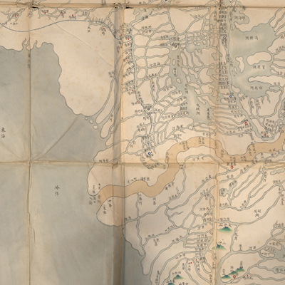
No title appears on the map; the title applied here is based on text on the upper left. The map depicts salt boat travel routes in four provinces: Jiangnan, Jiangxi, Huguang, and Henan. The text describes salt production and distribution in the Yangtze River and Huai River region. There are twenty salt fields south of the Huai River and three in the north. Notes also record the salt quota in each county.
The map is faded and the lower bottom part is torn off. North is on the bottom. It covers a wide area in central China, including the Yangtze River, the Yellow River, and the Huai River from Wan'an and Le'an County in Jiangxi Province and north to Wuyang County in Henan Province and Weishan Lake; east from the east coast and west to Lingbao and Guanxiang County in Shaanxi Province. The map depicts topographic and cultural features in various colors and symbols. Rivers are portrayed in lines; the Yangtze River and the Yellow River are in yellow; other rivers use blue; mountains are shown pictorially in green; provincial boundaries are delineated in red lines; embankments use blue lines; prefectures use squares; sub-prefectures use diamonds; counties use circles, and the locations of salt fields use red dots. Several errors appeared on the map: the locations of Dongting Lake, Wuchang County, and some other counties in Huguang Province are misplaced. The map was drawn in the early reign of the Qianlong emperor.
The salt industry was a chief source of national revenue for centuries in China and was a state monopoly. The government controlled and regulated the manufacture, transport, storage, market, and distribution of salt.
The map can be studied with the following maps in the National Palace Museum's collection: title: Hauihe liu yu tu (map no. 021486); title: Jiangsu nan he tu (map no. 021501); title: Huang Hui he tu (map no. 020874); title: Huanghe Huaihe liu yu tu (map no. 021566).