Military and Traffic Maps
泉州府輿地圖說
Illustrated Atlas of Quanzhou Prefecture| Hanyu Pinyin | Quanzhou Fu yu di tu shuo |
|---|---|
| Creator | Anonymous |
| Date | After the 30th Year of Ming Wanli Reign, 1602- |
| Measurement | |
| Techniques | Ink and color manuscript |
| Material | silk |
| Quantity | |
| Categories | |
| Country of Repository | |
| Identifier | Library of Congress |
| Link to Original Database | http://lccn.loc.gov/2002626790 |
| Share |
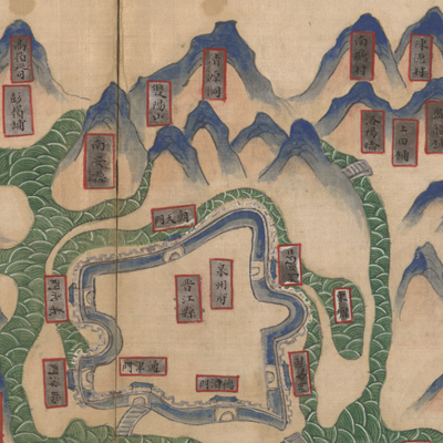
The atlas portrays Quanzhou as an important seaport and trading center on the southern coast in Fujian Province. Scale and orientation are not given. Each map is accompanied with explanatory text detailing the establishment and construction of the city. The maps illustrate the geographical locations, military units, trade and commercial activities, city establishments, and pirate activities throughout the prefecture. The map illustrate the natural geographical features in the prefecture, such as mountains, rivers, coasts, and islands as well as the layout of cities and distribution of military posts. Most geographical features are shown pictorially: mountains are represented by shapes of mountains; rivers by the shape of waves; special symbols represent different levels of government administration.
The atlas was created around 1602 during Emperor Wanli's reign. The purpose was to strengthen Quanzhou's sea fotifications to deter pirates.
The atlas can be studied with the following maps in the National Palace Museum's collection: title: Zhejiang Fujian yan hai hai fang tu (map no. 020869); title: Fujian Sheng di tu (map no.021476).