Flood Control and Embankment Maps
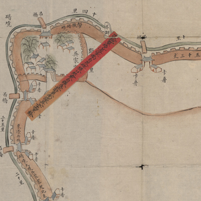
曹州府單縣南堤東濠圖
Embankment map of Shan County in Caozhou Prefecture| Hanyu Pinyin | Caozhou Fu Shan Xian nan di dong hao tu |
|---|---|
| Creator | Anonymous |
| Date | Late Qing period, 1856-1866 |
| Measurement | |
| Techniques | Ink and color manuscript |
| Material | paper |
| Quantity | |
| Categories | |
| Country of Repository | |
| Identifier | Library of Congress |
| Link to Original Database | http://lccn.loc.gov/73693312 |
| Acquisition Source | Rockhill, William Woodville, 1854-1914 |
| Acquisition Method | |
| Acquisition Date | 1904 |
| Share |
The title is written on a red label and pasted on the verso of the map. The map is oriented with north to the bottom and was not drawn to scale. The map depicts Shandong, Jiangsu, and northern embankment repairs near Shan County, Caozhou Prefecture; the map also contains the notations “Dry Yellow River is sixty six li” and information on embankment lengths, place names, and distribution of soldiers stationed at checkpoints. A red label describes the repair process of the “south embankment Donghao”, including specific data, efficacy, and the numbers of soldiers. Judging from the dry Yellow River and pasted red label on the map, it was not necessary to have any river works planned or done at this location. The map looks like a river construction map; in fact, it is more like a configuration map or a defense map submitted by local government for verification. The map was drawn after the Yellow River flooded in 1855.
The map can be studied with the following maps in the National Palace Museum's collection: title: Bei an si ting gong cheng zong he tu (map no. 020890); title: Cao Xian Huang He man kou du zhu wai di ji du sai tan kou qing xing tu (Grand Council file no. 027913-a); title: Caoheting shu Caoxiaxun xian zai he shi gong cheng qing xing tu (Grand Council file no. 050014); title: Cao Xian Anlingxun man kou gua yu qing xing tu (Grand Council file no. 027783-a).
The map can be studied with the following maps in the National Palace Museum's collection: title: Bei an si ting gong cheng zong he tu (map no. 020890); title: Cao Xian Huang He man kou du zhu wai di ji du sai tan kou qing xing tu (Grand Council file no. 027913-a); title: Caoheting shu Caoxiaxun xian zai he shi gong cheng qing xing tu (Grand Council file no. 050014); title: Cao Xian Anlingxun man kou gua yu qing xing tu (Grand Council file no. 027783-a).