General Maps
大明輿地圖
Atlas of the Ming Empire| Hanyu Pinyin | Da ming yu di tu |
|---|---|
| Creator | Anonymous |
| Date | Mid-Ming period, 1547-1559 |
| Measurement | |
| Techniques | Ink and color manuscript |
| Material | silk |
| Quantity | |
| Categories | |
| Country of Repository | |
| Identifier | Library of Congress |
| Link to Original Database | http://lccn.loc.gov/2002626776 |
| Acquisition Source | Warner purchase |
| Acquisition Method | |
| Acquisition Date | 1929 |
| Share |
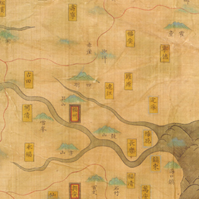
The map depicts Ming Dynasty's territory, administrative regions, mountains, and neighboring countries. Each map sheet is subtitled. The first map, “Yu di zong tu,” is a map of the entire Ming territory. Notes along the right bottom cite the Chinese scale as “each grid represents 500 li (approximately 155 miles). The map covers only state level administration excluding counties; the map shows the “Five Sacred Mountains” while omitting the rest." Only the first map sheet employs the traditional Chinese cartographic grid; the rest use the Chinese landscape painting style. Other maps in the atlas include two zhili states and thirteen provinces in the following order: North Zhili, South Zhili, Shandong (two, one is Liaodong), Shanxi, Henan, Shaanxi (two, Shaanxi and Gansu each), Zhejiang, Jiangxi, Hubei and Hunan, Sichuan, Fujian, Guangdong, Guangxi, Yunnan, Guizhou.
The atlas utilizes a set of uniform symbols as a legend to distinguish administrative government divisions and geographic features: cities are represented by rectangles; provincial capital cities are colored in yellow with red and black borders; district cities in yellow with a single red border line; the Yellow River in yellow; the Mongolian desert is a black belt; the mountains in green triangular symbols; and waves are shown with a traditional Chinese wavy pattern. Taiwan is not shown in the atlas; the neighboring countries and territories are excluded as well. This may reflect the closed-door policy of the late Ming period.
The atlas utilizes a set of uniform symbols as a legend to distinguish administrative government divisions and geographic features: cities are represented by rectangles; provincial capital cities are colored in yellow with red and black borders; district cities in yellow with a single red border line; the Yellow River in yellow; the Mongolian desert is a black belt; the mountains in green triangular symbols; and waves are shown with a traditional Chinese wavy pattern. Taiwan is not shown in the atlas; the neighboring countries and territories are excluded as well. This may reflect the closed-door policy of the late Ming period.